Planned Website Outage: The UAC website will be down for maintenance on June 17 from 2:00 - 7:00 PM MT.

Observation Date
12/30/2017
Observer Name
B
Region
Salt Lake » Big Cottonwood Canyon » Brighton Perimeter
Location Name or Route
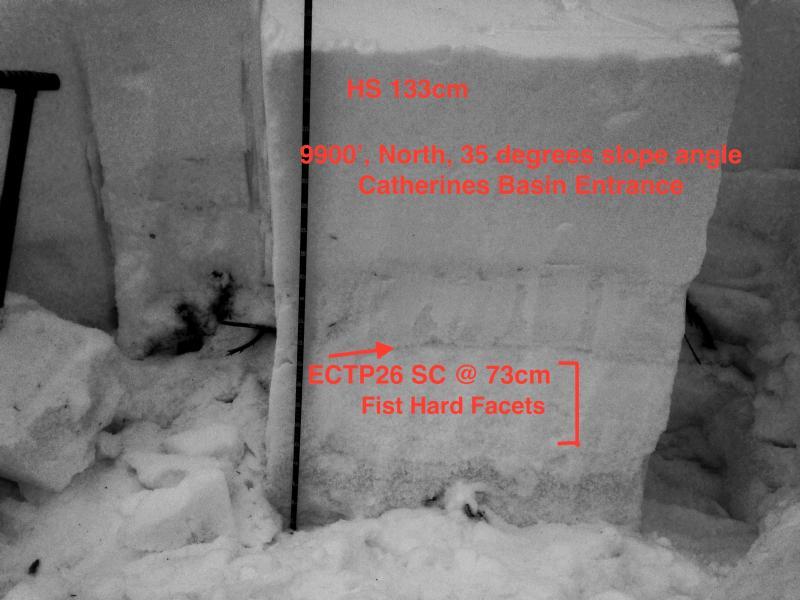
Brighton Perimeter: Catherines, Martha, Dog Lake
Weather
Sky
Overcast
Wind Direction
Southwest
Wind Speed
Light
Weather Comments
Skies remained overcast the entire day with no solar radiation issues. WSW winds were in the high end of the light category with light transport or wind blown observed. Temperatures remained unseasonably mild and warm.
Snow Characteristics
Snow Surface Conditions
Dense Loose
Wind Crust
Melt-Freeze Crust
Snow Characteristics Comments

Mixed bag out there for riding. The warm temperatures have settled the once winter like powder to spring like dense settled snow. In many areas there is significant wind damage with wind board and sastrugi. Southerly aspect did not soften today at mid and upper elevations. Overall, riding condtions have deteriorated in the past 48 hours.

Red Flags
Red Flags
Recent Avalanches
Wind Loading
Collapsing
Poor Snowpack Structure
Red Flags Comments
Observed collapsing once again today in a couple of isolated areas. Besides this, efforts at attempting to initiate remote triggering in safe likely areas were not successful. Reports of avalanches in the past 24 hours continues. Poor snowpack structure noted below in photo and snowpit results. At this point the upper elevation protected terrain in the Brighton Perimeter appears to be bridging the buried weak layers as the snowpack has adjusted to the Christmas storm load. Despite this, confidence remains low to get out onto steep terrain on NNW, N, NE and E aspects.
Avalanche Problem #1
Problem
Persistent Weak Layer
Problem #1 Comments

See above

Avalanche Problem #2
Problem
Wind Drifted Snow
Trend
Decreasing Danger
Problem #2 Comments

Isolated pockets of wind slab may continue to be an issue throughout the weekend in upper elevation terrain receiving winds in the teens and above.

Today's Observed Danger Rating
Considerable
Tomorrows Estimated Danger Rating
Considerable