Observation Date
12/24/2017
Observer Name
Greg Gagne with Tom Flaherty
Region
Salt Lake » Big Cottonwood Canyon » Silver Fork » West Bowl
Location Name or Route
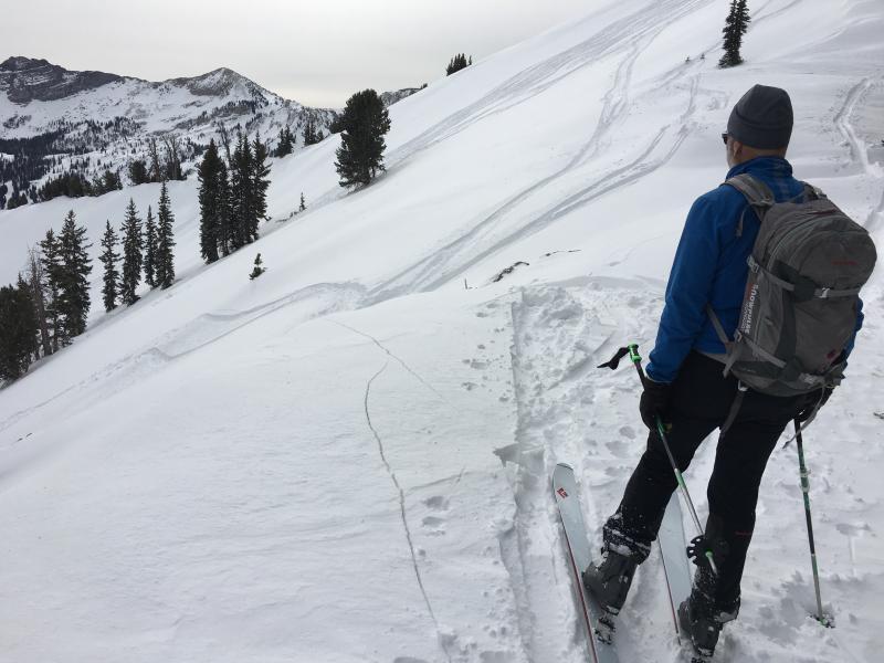
West Bowl of Silver Fork
Weather
Sky
Few
Wind Direction
Southwest
Wind Speed
Light
Weather Comments
Increasing high clouds with a beautiful sun dog sky in the early afternoon.
Snow Characteristics
New Snow Depth
12"
New Snow Density
Medium
Snow Surface Conditions
Powder
Wind Crust
Snow Characteristics Comments

Dense & surfy ski and travel conditions. Shallow ski pens (10 cms/4") Very difficult to determine snow amounts given how much wind had scoured and filled in terrain. HS 75-100 cms (2.5 - 3.5')

Red Flags
Red Flags
Recent Avalanches
Wind Loading
Cracking
Collapsing
Poor Snowpack Structure
Red Flags Comments
Not in your face instabiity as Saturday. Numerous smaller natural and skier triggered slides from Saturday found on ascent into West Bowl from Big Cottonwood. Also found one slope that had fractured and was triggered by wildlife (most likely coyote given the tracks we saw.) Difficult to tell weak layers given wind filled in many of these slides, but many look to have run on deeper, faceted layers.
Avalanche Problem #1
Problem
Persistent Weak Layer
Trend
Increasing Danger
Problem #1 Comments

Weaker, faceted layers are now down at least ~45 cms (18") and deeper where the slope has been wind loaded. Full propagation with extended columns between 10 and 15 taps failing on faceted layers deeper in the snowpack.

Will call for increasing danger with more snow and wind in the forecast.

Avalanche Problem #2
Problem
Wind Drifted Snow
Trend
Increasing Danger
Problem #2 Comments

Still getting lots of cracking in recent wind drifts. These are 1F or P hard.

Increasing danger with more wind forecasted for Christmas Day.

Comments

Weakest layers on Saturday were either a density inversion in the storm snow, or at the interface with the Wednesday storm. The storm slab weaknesses have settled out in the past 24 hours (these often settle out quickly) and although I did get one shear failure at the storm snow interface, today's stability tests were failing in faceted snow underneath the small Wednesday storm. These were full propagation, failing between 10 and 15 taps and Q1/SC or Q2/RP. Down ~45 cms (18")

With storm snow instabilities settling out, the deeper faceted layers were the weakest layers in the snowpack today. If we get decent water amounts (> .5") or wind loading overnight, am thinking avalanching will occur in these deeper faceted layers. With a deeper snowpack and slab on top, slopes are well-connected and avalanches may propagate widely.

Video showing one extended column on North aspect at 10,400'. ECTP15 failing down 45 cms (18") on a layer of facets. Of the extended column tests we performed, this was the least impressive with the least energy.

Video

Cracking on a wind-loaded slope on a steeper roll-over.

Conditions were clearly more stable than Saturday, and numerous tracks on steeper slopes in the backcountry. But persistent weak layers are notorious in conditions like this as the slab on top gains strength many people can ride slopes with no avalanching .... until someone finds a sweet spot.

Considerable hazard, but not widespread indications of instability - the type of conditions when accidents often occur.

Today's Observed Danger Rating
Considerable
Tomorrows Estimated Danger Rating
Considerable