Observation Date
12/24/2017
Observer Name
Paradis / Caplis
Region
Salt Lake » Park City Ridgeline » Murdock Peak
Location Name or Route
Murdock Peak
Weather
Sky
Clear
Wind Direction
South
Wind Speed
Calm
Weather Comments
Clear and calm in the morning but by about noon southerly winds and clouds picked up a little bit in advance of the approaching front.
Snow Characteristics
New Snow Depth
12"
New Snow Density
Medium
Snow Surface Conditions
Powder
Dense Loose
Snow Characteristics Comments
The wind from yesterday really determined what the snow was like today. Out of the wind, the snow was less consolidated but any location that got wind (including some spots relatively low down in the trees) had pretty dense wind affected snow. This gave the snow a somewhat upside down feel in spots. More importantly, there were plenty of obvious wind slabs. In some cases, the strong southerly winds had stripped and transported snow from south to north aspects to create these wind slabs.
Red Flags
Red Flags
Heavy Snowfall
Wind Loading
Cracking
Poor Snowpack Structure
Red Flags Comments
Lots of red flags from yesterday translated into caution today. Cracking was present, however was substantially less than yesterday afternoon.
Avalanche Problem #1
Problem
Wind Drifted Snow
Trend
Decreasing Danger
Problem #1 Comments
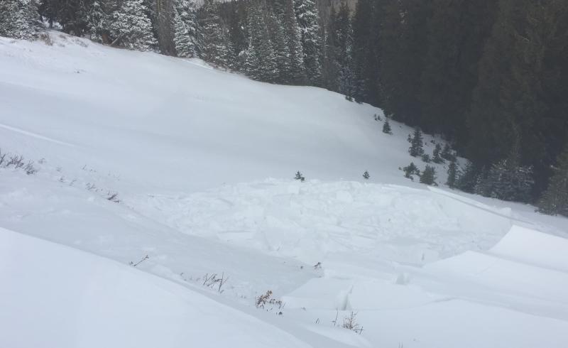
The new snow where it had not consolidated into a slab was only marginally softer than the underlying facets and although unstable, without a slab the avalanche danger wasn't too bad. Where the wind had formed wind slabs, these could be easily triggered (see photo below).
Avalanche Problem #2
Problem
Persistent Weak Layer
Trend
Increasing Danger
Problem #2 Comments
Widespread poor snowpack structure plus more snow tonight will allow yesterday's snow to further consolidate into a slab.
Snow Profile
Aspect
Northeast
Elevation
8,900'
Comments
In this location, the snow was wind protected enough to not have formed a slab. That said, the old snow was so weak that the column for the compression test failed on isolation.
Although this location has held snow since early October, I did not note the facet crust sandwich that I saw at Guardsman Pass and in Days Fork. Instead, the bottom most part of the snowpack was pretty firm.
This windslab was triggered from above with very little effort. In contrast to where we dug our pit, the wind had formed an obvious slab which when combined with weak existing snow, made for an easy avalanche.
Today's Observed Danger Rating
Considerable
Tomorrows Estimated Danger Rating
Considerable
Coordinates