Observation Date
12/22/2017
Observer Name
Catino
Region
Salt Lake » Big Cottonwood Canyon » Brighton Perimeter
Location Name or Route
Brighton>RockyPt>Dog Lake
Weather
Sky
Overcast
Wind Direction
West
Wind Speed
Moderate
Weather Comments
Sunny in the morning, but when I was out the overcast clouds and prefrontal winds WSW began to churn.
Snow Characteristics
New Snow Depth
4"
Snow Surface Conditions
Powder
Dense Loose
Snow Characteristics Comments
Mixed bag out there with yesterdays NE winds blasting Sunset Pk and Rocky Point, and now stirring from the other direction. Snow was blowing around and seemed less and more settled than yesterday's riding in LCC.
Red Flags
Red Flags
Wind Loading
Poor Snowpack Structure
Red Flags Comments
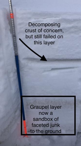
Went back to where Bruce and I dug a pit during the 12/4 storm [North facing Martha Bowl; at 9900' around 33 degrees]. Found the same crust [approx 25 to 30cm below the surface] which caused an ECTP, but it was decomposing. However, I was still able to get an ECTN around 14 and 15. It wasn't the quick Q1 shear, hence the two taps to get it to go, and more like a Q2, but it broke below the crust again. For reference on how much it would take to break into the junk below, I continued with my elbow taps and on 18, the whole column collapsed, failing on the facets near the ground and below the dirty graupel layer.
Avalanche Problem #1
Problem
Wind Drifted Snow
Problem #1 Comments
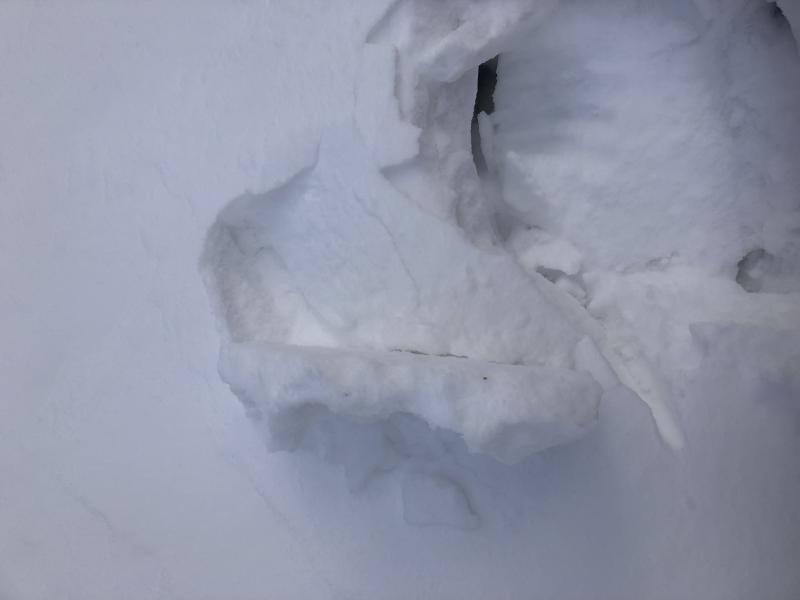
With winds ramping up again, these will need to be watched. I did see some cross loading and a fairly stout wind slab while cutting across from Brighton to Martha Bowl, and with more snow in the forecast these will become buried. Also noticed some minor wind drifting atop Rocky Pt from WSW winds and also atop the Dog Lake Chutes, opting to ski the skiers left and avoiding the fresh wind bulb at the top for good measure.
Avalanche Problem #2
Problem
Persistent Weak Layer
Trend
Increasing Danger
Problem #2 Comments
No surprise here, but with still not enough to tip the scale we'll need more than a few inches of duff. Maybe a couple of these storms and wind will finally wake the dragon.
Comments
Photos of snow pit and crust that may still be the layer of concern when we add some weight, with perhaps initial failures happening there then stepping down. Second photo of the stout wind slab from crossloading. Listed considerable for tomorrow for slopes on the north end of the compass if we receive a significant load.
Today's Observed Danger Rating
Moderate
Tomorrows Estimated Danger Rating
Considerable