Observation Date
12/21/2017
Observer Name
J. Rowell
Region
Salt Lake » Big Cottonwood Canyon » Bear Trap
Location Name or Route
Bear Trap Fork
Weather
Sky
Scattered
Wind Direction
Northeast
Wind Speed
Light
Weather Comments
Closest weather station (Canyons 9990) reported temps in the low teens throughout the middle of the day. Wind speeds averaged in the teens, gusting to low 20s. More sun than I expected.
Snow Characteristics
New Snow Depth
6"
New Snow Density
Low
Snow Surface Conditions
Powder
Snow Characteristics Comments
My first thought on the skin track this morning was, "oh my, I've forgotten what powder felt like"... The loose facet skiing wasn't so bad the past few weeks. But it's safe to say our party had our first powder day of the year in the Wasatch. 6 inches of low density fluff...just enough to ring in the first day of winter and cover up all the nasty rocks in the gully for the ski out.
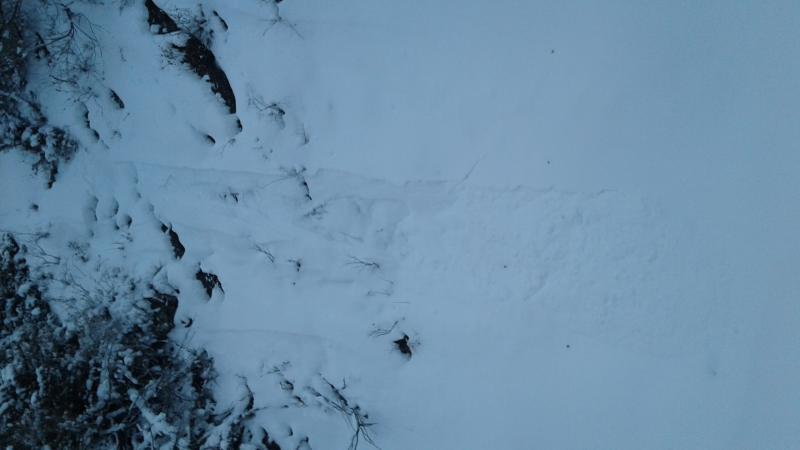
As expected, the new snow had not bonded well to the old rotten surface snow of the past few weeks. Below is a picture of a small natural dry loose in the gully, the only evidence of avalanche activity in the area. I was able to kick loose sluffs on steeper sections of the gully without much effort. I expect they'd be moving faster and farther on steeper and longer terrain.
Red Flags
Red Flags
Wind Loading
Poor Snowpack Structure
Red Flags Comments
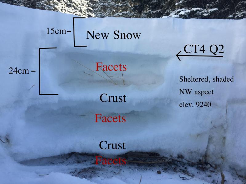
Below you'll see another picture of our poor snowpack structure. We all know (or should know) it's there. The news today would be how did our new load from yesterdays storm effect the snowpack. Was it enough weight to trigger that persistent layer avalanche? If not, were the winds strong enough to build a heavy enough slab?
Avalanche Problem #1
Problem
Wind Drifted Snow
Trend
Increasing Danger
Problem #1 Comments
Up in Beartrap glade we did not encounter any substantial windslabs. In this terrain we did not expect this to be a concern. I'm sure there are more interesting stories about windslabs in other observations.
Avalanche Problem #2
Problem
New Snow
Trend
Decreasing Danger
Problem #2 Comments
This is the only concern we encountered today. In the mellow terrain of Beartrap, it was not a problem. The new snow was still not enough to bury a person in this area. We considered skiing something off the Park City ridgeline, although ultimately we got caught up in the low angle fun zone. We would have been more concerned of this new snow sluffing in steeper terrain, especially areas with terrain traps.
Snow Profile
Aspect
Northwest
Elevation
9,300'
Slope Angle
25°
Comments
Very small dry loose natural in the gully of Beartrap Fork.
Pit depth: 64cm
Compression test produced a failure at 50cm at the new/old snow interface. The next failure was produced at around CT7 and broke above the next crust. This last storm was not enough of a load to produce big avalanches that our ticking time bomb facets are waiting for. Windloading or a storm with more water might produce these persistent slab avalanches. For now, I'll be watching my sluff and staying out of north facing windloaded terrain. Seems like a good window to get some powder skiing in.
Today's Observed Danger Rating
Moderate
Tomorrows Estimated Danger Rating
Moderate