Observation Date
12/4/2017
Observer Name
Greg Gagne
Region
Salt Lake » Big Cottonwood Canyon » Brighton » Millicent Peak
Location Name or Route
Brighton backcountry
Weather
Sky
Overcast
Wind Direction
North
Wind Speed
Calm
Weather Comments
Only a hint of wind.
Snow Characteristics
New Snow Depth
14"
New Snow Density
Low
Snow Surface Conditions
Powder
Snow Characteristics Comments

Right-side up storm with very low-density powder on top. Would have been a classic day had we a base underneath.

Storm total was roughly 30-40 cms (12-16") in upper BCC, although I did find one wind-drifted area with 45 cms on top of Thanksgiving crust.

Not much of a storm "slab" as it was so light, but generally poor bond to the existing snow surface.

No collapsing and only minor cracking in some pockets of wind drifts.

Red Flags
Red Flags
Poor Snowpack Structure
Red Flags Comments
Am finding weakest layer to be facets just underneath Thanksgiving crust.
Avalanche Problem #1
Problem
Persistent Weak Layer
Trend
Same
Problem #1 Comments

Few pits on northerly aspects between 9500' and 10,300' and it seems Thanksgiving crust was able to support storm load. Storm snow is so low density it is not a cohesive slab & only getting ECTNs above the Thanksgiving crust. I did get one result with a CT in the low 20's that failed in the faceted snow just below the crust. This was on a slope with 45 cms of storm and wind-drifted snow where the crust was much thinner (< 1 cm.) This made me think there may be some upper elevation northerly slopes where the crust is thinner and were wind-loaded that may be suspect where a failure would step into weak, faceted snow below the crust.

Comments

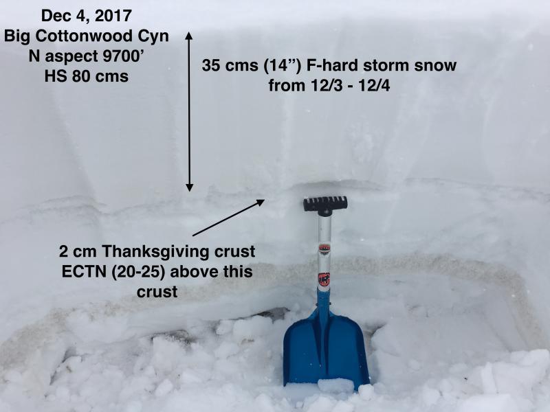
First photo illustrates snowpack where the storm snow is a low-density, uncohesive slab.

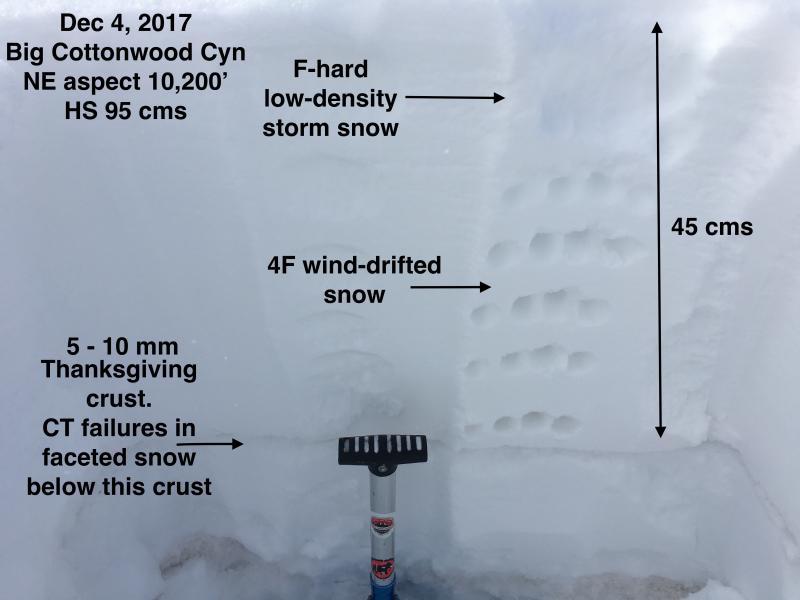
Second photo illustrates more of a load (45 cms / 18") of storm and wind-drifted snow on top of a thinner crust. I was able to get compression tests to fail in faceted snow beneath this crust. I think this setup is not that widespread, and would be found on upper elevation (> 10,000) northerly aspects that were wind-loaded.

Today's Observed Danger Rating
Moderate
Tomorrows Estimated Danger Rating
Moderate