Observation Date
11/22/2017
Observer Name
Brighton
Region
Salt Lake » Big Cottonwood Canyon » Brighton Perimeter
Location Name or Route
Brighton
Weather
Sky
Scattered
Weather Comments
Exceptionally mild morning with temps 2 C (mid 30's F).
Snow Characteristics
Snow Surface Conditions
Dense Loose
Melt-Freeze Crust
Rain-Rime Crust
Damp
Snow Characteristics Comments

Very warms temps have affected the snow surface. Rain crusts below about 9800', although I suspect it rained to higher elevations. Widespread thermal crusts across the compass. Top 10 cms (4") of the snow surface on northerly aspects > 10,000' were damp. These warm temps have stiffened up the slab from the Friday Nov 17 storm with a much more cohesive slab than I was finding last weekend.

The good news is that this recent stretch of warm weather had not faceted the storm snow as I was expecting, but there remains very weak snow underneath the storm snow.

Red Flags
Red Flags
Poor Snowpack Structure
Comments

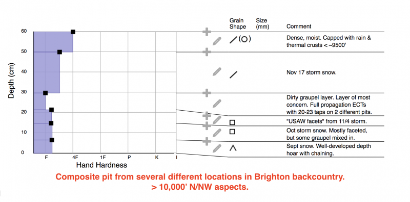
Below is a composite pit profile of what I was seeing from three different pits on N/NW aspects above 10k. (A "composite" pit profile attempts to summarize general findings, and not indicative of any one particular slope.) Area of greatest concern remains the ~10 cm (4") of dirty graupel, as well as the faceted layer below.

Two of my ECT's propagated across the column with 21- 23 taps (ECTP21 and ECTP23) failing in the dirty graupel layer down 30 cms (12"). Not much energy with Q2. Other columnar tests were ECTN, failing in the mid 20's on the graupel layer.

Also, on some quick hand pits the depth hoar down near the ground was somewhat damp.

I think it's possible a persistent slab could be triggered on a steep, upper elevation northerly aspect, but not likely.

Today's Observed Danger Rating
Low
Tomorrows Estimated Danger Rating
Low