Observation Date
11/19/2017
Observer Name
Kelly Robbins
Region
Salt Lake » Little Cottonwood Canyon » Albion Basin
Location Name or Route
Albion Basin
Weather
Sky
Clear
Wind Direction
Northwest
Wind Speed
Light
Weather Comments
Sunny skies, mostly calm with light gusts out of the North, cool in the shade, no precipitation.
Snow Characteristics
Snow Surface Conditions
Powder
Dense Loose
Wind Crust
Snow Characteristics Comments

Settled and supportable powder on the northerly aspects above about 9000 feet, although still an extremely shallow snowpack. Southerly aspects are rapidly losing their cover. Look for continued faceting in the thin north-facing terrain during this upcoming stretch of high pressure.

Red Flags
Red Flags
Poor Snowpack Structure
Avalanche Problem #1
Problem
Persistent Weak Layer
Problem #1 Comments

The weak faceted snow at the ground is comprised of both old snow from October, as well as old snow from the early November storms. The October snow contains well-developed 3-4 mm depth hoar, while the November snow still exists as primarily 1 mm facets. With only ~45 cm of new snow sitting on top of this from the Nov. 17 storm, the faceting process will continue on northerly aspects. Right now, the weakest snow seems to be the October snow. In a snowpit today, I witnessed an easy, sudden compression test result (CT5, Q1 or SC) about 60 cm from the surface, failing on depth hoar within the October snow. We'll be watching this layer for a LONG time.

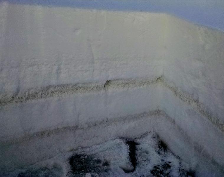
Photo is from a snowpit at 9600 feet on a 25 degree north-facing slope. Height of snow is ~70 cm, which includes 10 cm on the ground from October, capped by a friable rain crust, plus ~15 cm of small-grained facets from early November, plus ~45 cm from this latest storm. The pre-frontal graupel layer is clearly visible above the early November snow, and the weakest layer that I was mentioning earlier is seen in the grey line above the oldest October snow.

Today's Observed Danger Rating
Moderate
Tomorrows Estimated Danger Rating
Moderate
Coordinates