Observation Date
11/18/2017
Observer Name
Greg Gagne
Region
Salt Lake » Little Cottonwood Canyon » Catherine's Pass
Location Name or Route
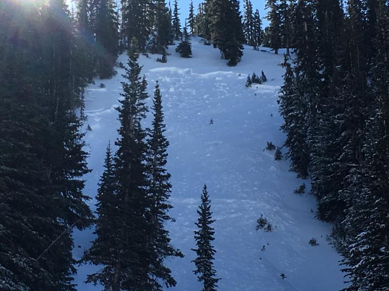
Catherine's Pass Area
Weather
Sky
Clear
Weather Comments
Clear & cool morning. Winds were nonexistent.
Snow Characteristics
New Snow Depth
15"
New Snow Density
Medium
Snow Surface Conditions
Powder
Wind Crust
Snow Characteristics Comments

About 35 cms (15") new in upper LCC. Total depth on some shady slopes close to 60 cms (2'), with less on solar aspects that had no prior snow. Some areas that had drifted had over 60 cms. Lots of graupel mixed in with storm snow. Storm came in dense but lightened up towards the end of the storm, creating a right-side up storm slab. The dense snow made for surprisingly easy travel given how thin our coverage is.

The few winds drifts I did encounter were not sensitive to stability tests.

Red Flags
Red Flags
Recent Avalanches
Heavy Snowfall
Wind Loading
Poor Snowpack Structure
Red Flags Comments
Despite jumping around on all sorts of test slopes that had weak snow underneath, I could not get any collapsing in the snowpack.
Avalanche Problem #1
Problem
Persistent Weak Layer
Trend
Same
Problem #1 Comments

We now have a persistent slab issue with a dense slab on top of weak faceted snow down at the ground. Currently, the weakest layer in the snowpack is a 5 cm (2-3") layer of graupel that fell early in the storm. This was the weak layer for an avalanche that occurred just west of Catherine's Pass. Where this graupel layer was prevalent, column tests were failing on this layer. Where there was less graupel, column tests were failing with easy shears down 40 cms in various layers of faceted snow from Sept, Oct, and early Nov storms.

This graupel layer will linger for short while, but heal. The weak, faceted snow underneath the storm snow on NW through NE aspects will persist.

Comments

The only avalanche activity we noted was a large natural in the East Castle area of the currently close Alta resort. Am expecting the details of this to be posted elsewhere.

Otherwise, we found an avalanche that occurred sometime during the storm on Friday that ran on a layer of graupel that fell early in the storm. (Radar images taken mid-day Friday showed a period of convective activity where this graupel layer likely formed.) Am unsure if this slide was a natural or skier-triggered as there may have been some evidence of a track adjacent to the slide. (Also reported this slide as an avalanche occurrence.)

Clearly the slope was unstable during the peak of the storm with a weak layer of graupel and a rapidly-loading slab on top. But this morning the slab had relaxed quite a bit and could get clean shovel shears, but no propagation on a few different extended column tests (ECTX).

Video

Recent avalanching and persistent weaknesses within a poor snowpack structure indicates a Considerable hazard on upper elevation NW through NE aspects.

Today's Observed Danger Rating
Considerable
Tomorrows Estimated Danger Rating
Considerable