Observation Date
11/18/2017
Observer Name
B
Region
Salt Lake » Big Cottonwood Canyon » Brighton Perimeter
Location Name or Route
Brighton Perimeter: Hidden Canyon, Snake Creek
Weather
Sky
Clear
Wind Direction
Northwest
Wind Speed
Calm
Weather Comments
Unseasonably cold temperatures in the early am and throughout the day. Clear Skies with the Winds basically nonexistent. No transport and or wind blown observed. Of note, skies cleared in the middle of the night.
Snow Characteristics
New Snow Depth
12"
New Snow Density
Medium
Snow Surface Conditions
Powder
Wind Crust
Snow Characteristics Comments

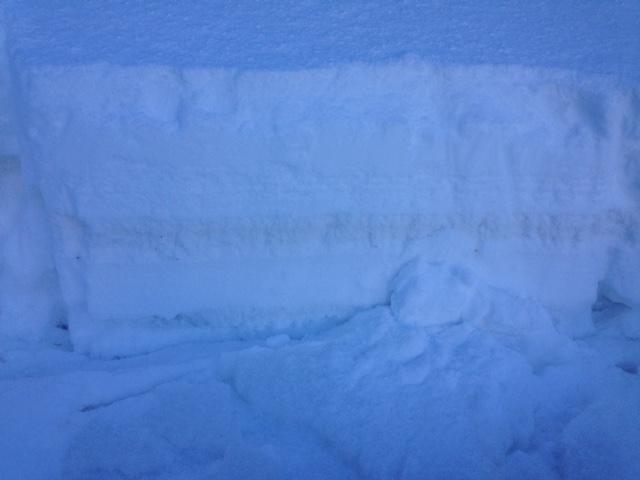
Surface forms mixed grains with patches of SH scattered over graupel and rimed PP. New snow from the latest event came in warm with initially at least 3 inches of graupel, and as the storm progressed the temperatures dropped signficantly with frontal passage. As a result the storm was mostly rightside up. Of note, the winds were in the moderate to strong range for most of the event with the last four inches falling with calmer wind velocities. Storm totals in the Brighton area appeared to hit 18 inches with significant settlement occuring overnight. At 0700 height of new snow was 12 inches at elevation. At 8000 feet in Silverfork storm totals were 13 inches with overnight settlement taking the new snow height down to 9 inches. Water content appeared to be close to 2 inches.

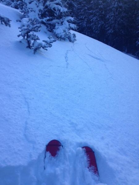
Riding conditions were excellent from 8700 feet up to the ridges, with most exposed ridgelines and terrain features having wind sculpting and thicker drifts. Ski penetration was 4 to 6 inches. Pole probes appeared to indicate a possible punchy structure, but this was not noticible when riding.

South facing slopes with angles 25 degrees and greater got damp a mid elevations by the mid afternoon hours.

Red Flags
Red Flags
Heavy Snowfall
Wind Loading
Cracking
Collapsing
Poor Snowpack Structure
Red Flags Comments
No recent activity observed. Heavy snowfall on Friday with abundant water has appeared to tip the scales with the poor snowpack structure that was in place. Upper elevation slopes above 9300 on NW, N and NE aspect were housing varying depths of preseason faceted snow. Northerly facing 30 degree slopes were not yielding any indications the new load was enough; yet on a N facing 31 degree slope in Hidden Canyon widespread cracking and collapsing occured when taking off one ski to test for foot penetration and dig a pit. See photos, spiderwebbing occured with propagation traveling back up slope even on the lower angle slopes. Snow pit tests at 9850 feet, N facing on a 31 degree slope yielded an ECTP21,SC, Q1. The failure occured in 1.5 to 2 mm facets 9 inches up from the ground, directly above a melt freeze crust that was formed on top of the first seasons snowfall from September 16. Initiation occured in these facets and then stepped down to the fist hard/unconsolidated DH.
Avalanche Problem #1
Problem
Persistent Weak Layer
Trend
Same
Problem #1 Comments

See above test results and photo below of pit and end result of ECT. Of note, there are two distinct (and weak) faceted grauple layers that are easily visible in the photo. Human triggered full depth slides in northerly facing upper elevation terrain wiith angles 35 degrees and greater possible.

Of note, with the abunance of grauple associated with the latest event Loose Dry avalanching and sluffing was easy to initiate on steep slopes, and these could help trigger something lower in the snowpack.

Avalanche Problem #2
Problem
Wind Drifted Snow
Trend
Decreasing Danger
Problem #2 Comments

With the excessive winds observed on 11/17 during the storm, steep mid slope upper elevation roll overs may be suspect as well as the typical ridgeline pocket areas. The winds appeared to be out of the WSW initially and trended more out of the WNW in the later part of the event.

It appears that there were no natural avalanches in the areas traveled and besides sun induced Loose Wet avalanches on steep southerly facing terrain the major issues are related to the potential for Persistent Slab. As a result the Danger appears to be Moderate, but with high consequences due to the potential for full depth slides and any avalanche taking you into rocky runouts. This Danger is isolated to upper elevation NW, N and N facing terrain with angles 35 degrees and greater, and it appears that this hazard will be with us for a while.

Snow Profile
Aspect
North
Elevation
9,800'
Slope Angle
30°
Today's Observed Danger Rating
Moderate
Tomorrows Estimated Danger Rating
Moderate