Planned Website Outage: The UAC website will be down for maintenance on June 17 from 2:00 - 7:00 PM MT.

Observation: Provo Canyon

Observation Date
3/16/2017
Observer Name
Joey Dempster
Region
Provo » Provo Canyon
Location Name or Route
Aspen Grove, Coyote Ridge
Weather
Sky
Clear
Wind Direction
Southwest
Wind Speed
Moderate
Weather Comments
43 degrees in the Aspen Grove parking lot as the sun was rising. Moderate winds with strong gusts out of the SW up on the ridges, but there was no snow available for transport so the only real effect was a bit of cooling. It didn't help much.
Snow Characteristics
Snow Surface Conditions
Melt-Freeze Crust
Damp
Snow Characteristics Comments

Poor to non-existant refreeze. Mid-elevation slopes with southerly exposure that have been picking up the most heat were not supportable this morning. Below 8000 feet south facing snow is shallow and incohesive. N facing mid-elevation treed slopes had very unattractive mank that I wouldn't want to ski, but was quite stable. At 9:30 when I descended, E facing slopes between 8k-9k were already wet and breakable. W facing was the best option, but it was variable, with occasional patches of unsupportable crust. Below 8k (as noted above), things deteriorated rapidly. If I had to do it over again, I would probably take my chances with the N facing mank, because corn is non-existent now below 9000 feet. It might be a good time to give in to the peer pressure and go biking.

Red Flags
Red Flags
Recent Avalanches
Rapid Warming
Poor Snowpack Structure
Red Flags Comments
I observed two avalanches of significant size, one skier triggered. Warm temperatures have rapidly deteriorated the skiing conditions and increased the avalanche hazard since Tuesday when I found more normal spring conditions. Below 8000 the snowpack exhibits poor structure, and is often totally incohesive. It is very easy to push ski width wet avalanches down very steep slopes at this elevation.
Avalanche Problem #1
Problem
Wet Snow
Problem #1 Comments

Poor to non-existant refreeze has increased the avalanche hazard at the mid elevations to considerable on very steep slopes (slope angles in the upper 30s and above). That is to say that human triggered wet point-release avalanches are likely on steep slopes with exposure to the southern half of the compass (E, S, W). I did not travel above 9000 feet, but I would expect conditions to gradually become more moderate above that threshold. Below 8000 feet, southerly facing slopes with steepness greater than 35 degrees should be scrupulously avoided.

Comments

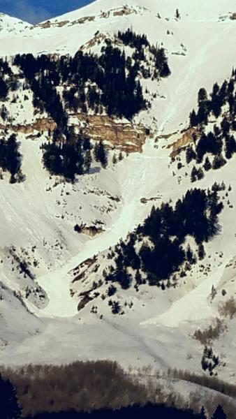
This is a photo of an avalanche that most likely occurred on Wed. 3/15/17. This is the "Jesse James" slide path off of East Peak that runs out across the Sundance Nordic Center. It appears that this started as a large sluff near the top of the path, then triggered a slab avalanche beneath the big cliff band in the middle of the path. The debris pile is quite large. The take-home point here is that even this large avalanche leaves a lot of snow left for multiple rounds of the same type of slide. I think we're heading into a period where these slides will be numerous and potentially destructive in the next few days.

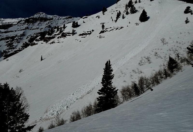
This is a classic skier-triggered wet slide that starts as a ski-width sluff and quickly entrains more snow and fans out. It's hard to tell from the photo, but the deposition is large, definitely deep enough to bury a person. Some of the chunks of snow in the debris are 4-6 feet in diameter. From the tracks, it appears that the skier was able to avoid being caught. I would expect that this type of avalanche could be triggered more often than not on similar slopes. This slope faces SE and is an estimated 37-38 degrees in steepness.

Today's Observed Danger Rating
Considerable
Tomorrows Estimated Danger Rating
Considerable