Two morning runs on north-facing Lawnmower on Kessler. Lots of quick pits ascending to the top of the ridgeline, as well as pits at top of Lawnmower run.
Looking at the following concerns:
- Recent wind loading:
I could not find any fresh wind drifts, but it is likely we were in a wind-protected area from recent strong winds.
- Storm snow interfacing with (1) faceted snow that formed over this past weekend, (2) few cms of very light stellars that fell on Saturday, and (3) layer of radiation recrystallization (RR) facets that formed on some east and southeast aspects on sunday.
All pits were showing storm snow has bonded well to old snow surface. Drew and Zinnia Wilson had a good observation from Sunday where they noted the old snow surface was not especially weak. I also dug around on east aspects that had crusted and was finding a good bond as well, so it is likely any RR facets were destroyed in pre-frontal winds (as is often the case.)
- Sensitivity of storm snow. Storm came in right-side up, and although there was a cycle during the storm on Monday, no sensitivity in the storm snow was found at all. The storm snow was soft 4F and not a cohesive slab.
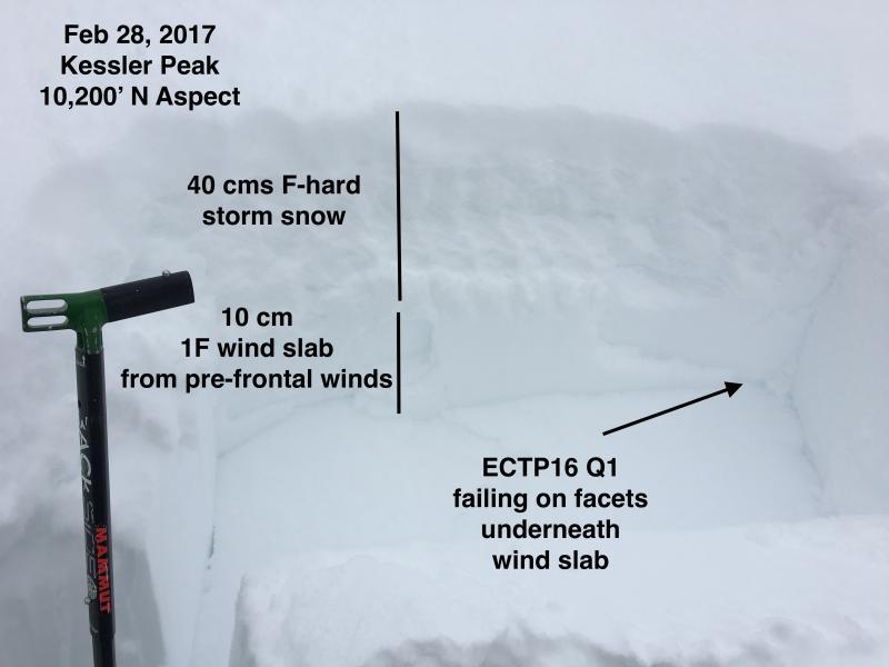
All pits were showing poor quality Q2 or Q3 shears with good bonding and no obvious weak layers. However, we did get one pit at the very top of the Lawnmower that caught our attention: full propagation with Q1 shear at 16 taps (ECTP16 Q1) failing down 50 cms on a layer of facets sitting underneath a 10 cm wind slab that had likely formed from the pre-frontal winds later Sunday (photo below.) All other evidence was showing a stable snowpack where we were traveling, and we could not duplicate this structure elsewhere. After getting these results, a few other nearby pits were getting ECTN 15-25. Felt this was very isolated and I just happened to dig in the right spot.
Where we were traveling overall hazard was Moderate for loose sluffs and perhaps a rogue small pocket that might pull out. Likely fresh wind drifts at upper elevations that are more exposed to the wind.