Observation: Murdock Peak

Observation Date
1/22/2017
Observer Name
Paradis / Brackelsberg / Caplis
Region
Salt Lake » Park City Ridgeline » Murdock Peak
Location Name or Route
Murdock Peak
Weather
Sky
Overcast
Precipitation
Light Snowfall
Wind Direction
Southwest
Wind Speed
Calm
Weather Comments
Before about 2:30pm skies were mainly overcast. The sun even attempted to come out. After 2:30 light to moderate snow started which limited visibility a bit. We were a bit suprised that the wind was so light prior to the advancing front.
Snow Characteristics
New Snow Depth
8"
New Snow Density
Low
Snow Surface Conditions
Powder
Snow Characteristics Comments

South and west aspects had a little melt freeze crust which made the skiing feel a little dust on crust-ish. Elsewhere old snow was less noticeable and skied well.

Red Flags
Red Flags
Recent Avalanches
Heavy Snowfall
Poor Snowpack Structure
Red Flags Comments
We found spotty surface hoar and NSF today which checks the box above for poor snowpack structure. The surface hoar (photo below) seems very spatially variable. Seems like out the the wind there wasn't all that much new snow (~8") and it wasn't all that slabby in areas travelled today. In the wind, it was a different story with plenty of obvious wind slabs. We saw another group ski nearby and only create loose avalances, suggesting not enough of a slab had formed. The surface hoar in these windy spots was probably also destroyed.
Avalanche Problem #1
Problem
Wind Drifted Snow
Trend
Increasing Danger
Problem #1 Comments

Strong winds from prior days had created obvious wind slabs in exposed areas. This will increase with more snow and wind.

Avalanche Problem #2
Problem
Persistent Weak Layer
Trend
Increasing Danger
Problem #2 Comments

With more snow and wind on the way, more cohesive slabs will likely form above weaknesses created from the past week of high pressure.

Snow Profile
Aspect
North
Elevation
8,800'
Slope Angle
25°

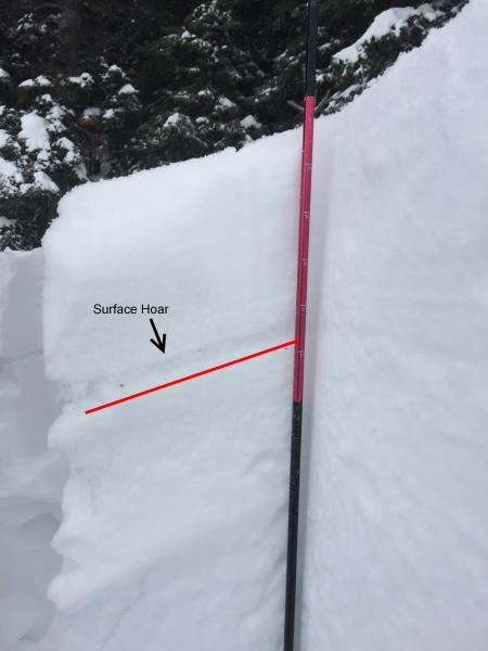
Buried surface hoar was easily visible in the photo above. As noted above, this is probably high spatially varible.

Today's Observed Danger Rating
Considerable
Tomorrows Estimated Danger Rating
High