Observation Date
1/10/2017
Observer Name
John Mletschnig
Region
Salt Lake » Big Cottonwood Canyon » Greens Basin
Location Name or Route
Greens Basin and Silver Fork
Weather
Sky
Obscured
Precipitation
Moderate Snowfall
Wind Direction
Southwest
Wind Speed
Moderate
Weather Comments
Overcast in the morning from 0900 to 1230 with little precipitation and light to moderate winds from sw then light to moderate snowfall the rest of the afternnon with moderate winds.
Snow Characteristics
New Snow Depth
8"
New Snow Density
Medium
Snow Surface Conditions
Powder
Snow Characteristics Comments

Snow surface was dry moderate density powder from Spruces CG to 9600'. A crust from earlier warm and wet conditions was noticeable at times skiing below 8500' down 8'' or so from the surface. At ridge level the snowpack is sculpted by the wind into a dense slab.

Red Flags
Red Flags
Heavy Snowfall
Wind Loading
Cracking
Poor Snowpack Structure
Red Flags Comments
Rapid loading in the afternoon. High Precepitation Intensity during afternoon. Propagation noted in Extended Collum Test at 9400'. Moist facet layers in snowpack, weak in strength at 8000'. Cracking observed in top 30cm. No collapsing or avalanches observed.
Avalanche Problem #1
Problem
Wind Drifted Snow
Problem #1 Comments

Leeward slopes of mid and high elevation ridges contain sculpted hard slabs which if triggered would likely cause wider than average avalanches linking together multiple slopes, possibly over terrain features.

Avalanche Problem #2
Problem
New Snow
Problem #2 Comments

Crystal change layers within the new snow are slow to adjust to the rapidly loading snow surface. Propagation is likely on slopes steeper than 30 degrees above 8500'. Areas with overlaying slab consolidation will exacerbate these problem layers (ie wind loading or additional surface snow and/or settlement).

Snow Profile
Aspect
Northeast
Elevation
9,400'
Slope Angle
31°
Comments

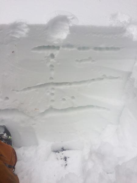
At elevations above 8500' wind slab and storm snow weaknesses are prevalent requiring great care. A crystal change within the new snow down 30 cm gave full propagation results at 9400', NE, 31 deg. ECTP11, Resistant Planar shear ( see video)

At elevations below 8500' several saturated faceted layers were observed in the snowpack. The most pronounced being at 2/3 depth below what is likely the mid December rain crust. No propagation was observed in a pit at 8000', W, 25 deg. but Q2 failures and collapses below Dec 16 rain crust on 3mm moist facets and 2mm moist facets closer to the ground was observed in Compression Tests with low end moderate scores in strength.

Video

A crystal change within the new snow down 30 cm gave full propagation results at 9400', NE, 31 deg., Meadow Chutes -- ECTP11 x2, Resistant Planar shears. *** pit was not on a very steep slope, steeper slope likely would have yielded sudden planar results. see video.

Separate pit at 8000', W, 25 deg. on Days - Greens Basin ridge. New snow with groupel layer down 10 cm then moist facet layer below Dec 16 rain crust (ECTN 12, CT12 Q2) and moist facet layer down 60cm (CT12 Q2)

Today's Observed Danger Rating
Considerable
Tomorrows Estimated Danger Rating
High
Coordinates