Observation Date
1/9/2017
Observer Name
John Lemnotis
Region
Salt Lake » Big Cottonwood Canyon » 10420
Location Name or Route
10420
Weather
Sky
Obscured
Precipitation
Moderate Snowfall
Wind Direction
North
Wind Speed
Moderate
Weather Comments
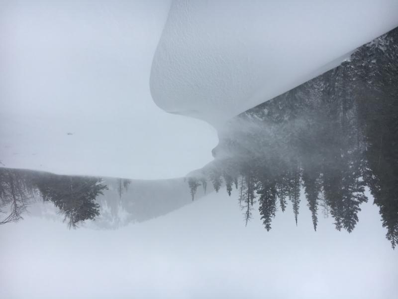
Most notably the wind was consistent during our tour. Continuously moderate with strong gusts transporting lots of snow. Snowfall was mostly moderate and eventually stopped by our exit around 1:30. It's tough to tell how much new snow actually fell due to the wind today.
Snow Characteristics
New Snow Depth
4"
New Snow Density
High
Snow Surface Conditions
Powder
Dense Loose
Wind Crust
Snow Characteristics Comments
Most of the surface was wind affected, either scoured or loaded depending on the aspect. North aspects were actively being loaded throughout the tour while S faces were thin. Sheltered slopes in the trees held creamy turns in the dense new snow that hadn't been transported. Hand pits and shovel shears showed the new snow bonding poorly to the old snow surface by releasing easily down 10 to 15cm.
Red Flags
Red Flags
Heavy Snowfall
Wind Loading
Cracking
Collapsing
Red Flags Comments
The biggest flag for me is the wind loading. Ski pen was around 10cm while boot pen was 30 to 45cm... Lots of snow available for transport and it was moving. Cracking in fresh wind loaded areas and it was easy when kick turning to get the new snow to release above the skin track. One collapse was noted when traversing under a low angle wind loaded zone.
Avalanche Problem #1
Problem
Wind Drifted Snow
Trend
Same
Problem #1 Comments
It was easy to see the snow moving around today loading N facing aspects and forming abnormally large cornices and wind loaded rollers for this time of year in the area around 10420. Cracking around our skis in the freshly formed wind slabs was evident and older more firm slabs were stubborn but would crack if you jumped on them. The winds will continue through the night with more snow so this will be a sensitive issue tomorrow as well.
Avalanche Problem #2
Problem
Persistent Weak Layer
Trend
Increasing Danger
Problem #2 Comments
There are still weak layers present deeper in the snow pack. I think the concern with this storm would be the large amount of water being dropped on the pack despite the low snow totals, this load could trigger instabilities near the surface like some of the NSF or graupel still present then step down to those deep instabilities. Increasing danger until the storm passes.
Comments
Video is of an ECT at 10300' NE facing 26 degree slope below peak 10420. Fast forward to 46 seconds where the taps from the elbow start. ECTP12 on a layer of preserved graupel with a hardness change below.
Video
Not sure why my photos load wrong side up but lots of wind is the moral of the story.
Today's Observed Danger Rating
High
Tomorrows Estimated Danger Rating
High