Observation Date
1/7/2017
Observer Name
B
Region
Salt Lake » Little Cottonwood Canyon » Snowbird periphery
Location Name or Route
Snowbird Periphery
Weather
Sky
Overcast
Precipitation
Moderate Snowfall
Wind Direction
Southwest
Weather Comments
Early morning Broken Skies gave way to Overcast skies, and Moderate Snowfall during a brief short wave disturbance around 1430. A quick 3 cm of Light Density Fell with Moderate Winds. Winds were mostly in the Light Range with sporadic gusts in the Moderate Category even at mid elevations. Transport was Moderate with Wind Blown observed well down in the drainages as well on most ridgelines. Cross Loading was observed on many Upper Elevation Large Bowls and Terrain Features.
Snow Characteristics
New Snow Depth
1"
New Snow Density
Low
Snow Surface Conditions
Powder
Wind Crust
Snow Characteristics Comments

The upper 8 to 10 cm consisted of a cohesion-less layer with NSF's observed on the Surface. Riding conditions were still excellent on all aspects from mid elevations up to at least 9500 feet. Wind Crusts were observed on exposed W and SW facing terrain.

Red Flags
Red Flags
Recent Avalanches
Wind Loading
Red Flags Comments
As reported from the Southern Wasatch Natural Avalanches were occuring today. With Winds and abundent snow available for Transport, it would be realistic to speculate that there were other such occurances in the other upper elevation wind loaded terrain, and mainly on NE through E. Of Note; CTM RP Scores were obtained at Mid Elevations on WNW through SW aspects. Layers illustraing these weaknesses were at 25 cm down and 60 cm down. The weak layer at 25 down was a preserved layer of Light Density Stellars. And, the weak layer observed at 60 cm down appeared to be the same graupel layer that may have been responsible for the Slide reported from Cadiac Ridge just today. This Graupel layer was showinig signs of rounding and sintering.
Avalanche Problem #1
Problem
Wind Drifted Snow
Trend
Increasing Danger
Problem #1 Comments

As stated above Wind Slab development and release were Likely on today, even though the areas traveled were not offering any such activities. And, the forecast for continued Moderate to Strong SW Winds indicate this issue/Problem may be escalating.

Avalanche Problem #2
Problem
New Snow
Trend
Increasing Danger
Problem #2 Comments

FTest results in the cohesion-less upper 10 cm of surface snow illustrated the potential for Loose Dry Avalanches/Sluffs to be common in steep terrain on all aspects.

For Saturday, the Danger appeared to be Considerable in Wind Loaded areas, and these would most Likely be in the upper elevations on N-NE aspects.

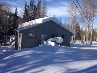
Sounds like everyone needs to pull out there most water resistant gear for Sunday with the forecast of rain up to 8000 feet. And if the forecast verifies, there may be a few Avalanche Concerns; 1.) Rain on Snow from 8000 down means Rain on Cold Snow that has not yet been warmed significantly; and this includes a widespread area like the Lower Canyons and the benches in the Salt Lake Valley. Another concern is Roof Avalanches (See Photo below). This changing weather pattern combined with Strong SW Winds and abundant moisture appears to be a recipe for Widespread Natural Wet Activity. Plus with the Light Density Snow that may fall overnight on the 7th, there appears to be the potential for Dense Slabs being reactive on this Lighter Layer.

For Sunday, the Danger will start out as Considerable as identified above, and most Likely will escalate to High later in the day when the Precipitation rates pick up combined with the unseasonable warm temperatures forecast.

Picture of remaining hang fire and Roof Avalanche Slab taken 8 days ago in Brighton, and there is now at least another 2 feet in that area; and with the cold temperatures this past week it has not yet released.

Today's Observed Danger Rating
Considerable
Tomorrows Estimated Danger Rating
High