Observation Date
1/5/2017
Observer Name
Mletschnig
Region
Salt Lake » Mill Creek Ridgeline
Location Name or Route
Upper Millcreek and Park City Ridge
Weather
Sky
Overcast
Precipitation
Light Snowfall
Wind Direction
Northwest
Wind Speed
Light
Weather Comments
Temperatures were cold in the mornong with light snow and calm winds. In the afternoon the sky remained overcast with only a few bit of sun poking through. Winds were light from the wnw.
Snow Characteristics
New Snow Depth
10"
New Snow Density
Low
Snow Surface Conditions
Powder
Dense Loose
Snow Characteristics Comments
light density snow fell overnight as temperatures plummeted from yesterdays warm new snow inversion layer. Winds easily moved the light snow to lee areas along ridges overnight and in the early morning.
Wide skis helped stay in the surface snow above the density inversion and overall the skiing was good in protected areas! Much of the south facing terrain in upper mill D was fairly wind affected.
Red Flags
Red Flags
Recent Avalanches
Wind Loading
Poor Snowpack Structure
Red Flags Comments
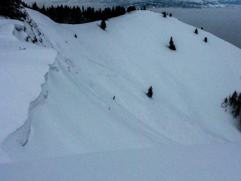
Evidence of natural soft slab release observed on steep, wind loaded, easterly facing slope along PC Ridge in Red Pine canyon.
Cracking observed in top 20 cm along ridges. No collapsing observed.
Avalanche Problem #1
Problem
Wind Drifted Snow
Problem #1 Comments
The new snow contains a density inversion down about 10 inches or so in sheltered areas, perhaps more in places. Areas which received loading, primarily mid to upper elevation NW--N-NE-E-SE will be most affected by this and are most suspect in terms of stability.
Avalanche Problem #2
Problem
Persistent Weak Layer
Problem #2 Comments
The now 50 plus cm of storm snow sitting on top of old near surface facets on nw-n-ne-e-se requires some respect. At 9375 on a northerly slope in Upper Millcreek Canyon the layer proved difficult to initiate propagation in stability tests but the existing structure could be worse off in other areas such as those in higher elevations.
Snow Profile
Aspect
Northwest
Elevation
9,400'
Slope Angle
25°
Comments
ECTN15 down 17cm on new snow density inversion, ECTN21 down 20cm on new snow density inversion. CT12 down 17cm Q2, CT15 down 20cm Q2, CT23 down 50cm (on NSF) Q3. Pit location was protected, if tests were done in a more wind loaded location propagation results would likely have been more reactive with surface instabilities.
Evidence of natural soft slab release observed on steep (40deg), wind loaded, easterly facing slope along PC Ridge in Red Pine canyon, 9550'. Looked like primarily surface snow 20-30cm deep x 150' wide, ran 500', stopped in top of runout. size 1.5.
Today's Observed Danger Rating
Considerable
Tomorrows Estimated Danger Rating
Considerable
Coordinates