Observation Date
1/2/2017
Observer Name
Greg Gagne with Patrice Duvernay
Region
Salt Lake » Big Cottonwood Canyon » Mineral Fork
Location Name or Route
Mineral Fork
Weather
Sky
Overcast
Precipitation
Moderate Snowfall
Wind Direction
West
Wind Speed
Light
Weather Comments
Occasional bursts of heavy snowfall in the early afternoon. Very light winds up to 9300' (our highest elevation.)
Snow Characteristics
New Snow Depth
8"
New Snow Density
Low
Snow Surface Conditions
Powder
Snow Characteristics Comments
When exiting at about 1500, there was 20 cms (8") new at 9000', with lesser amounts below that elevation. Very low density fluff!
Red Flags
Red Flags
Heavy Snowfall
Red Flags Comments
Spike in snowfall in the early afternoon made for initaiting very easy sluffs in the storm snow on slopes > ~ 33 degrees. Poor visibility, but wouldn't be surprised if there was a small natural cycle in some terrain during this time.
Avalanche Problem #1
Problem
New Snow
Trend
Increasing Danger
Problem #1 Comments
Storm snow was sluffing quite easily on steeper terrain. Given there wasn't that much storm snow, it was very easy to manage and mitigate as ski cuts were quite effective. Will identify the problem as increasing danger, but it should settle out fairly soon once snowfall winds down.
Avalanche Problem #2
Problem
Persistent Weak Layer
Trend
Increasing Danger
Problem #2 Comments
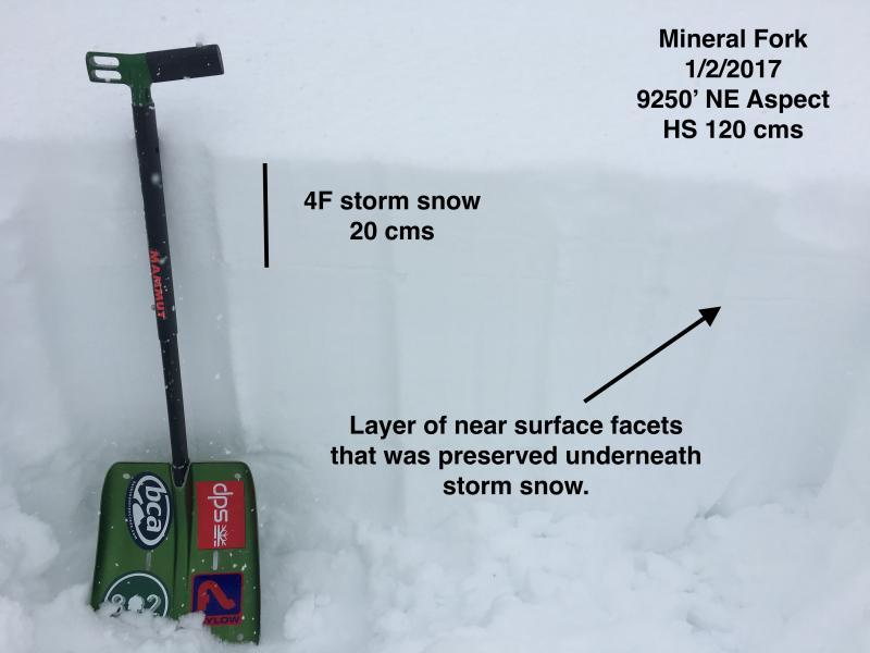
The layer of NSF that formed from the clear spell this past Thursday through Sunday was preserved underneath the storm snow. The 15-20 cms (6-8") of storm snow wasn't enough of a cohesive slab to make this layer reactive, but with additional snow overnight - as well as more expected throughout this week - I wouldn't be surprised to see failures at this weak layer. For today it was not really an issue where we were traveling but am guessing this may become an issue as unsettled weather is expected this week. (Footnote: I did see Mark White's obs from PC ridgeline where it was an issue today!)
Comments
Overall Moderate hazard where we were traveling today with sluffing within the storm snow the primary avalanche hazard. It was quite manageable with effective ski cuts on steeper rollovers. The preserved layer of NSF currently not a concern today as today's storm snow was very soft and not acting as a cohesive slab, but may become a concern with additional snow.
Photo shows the upper 75 cms of the snowpack, highlighting the preserved layer of NSF now down 15-20 cms (6-8")
Video discussion of the storm snow, and preserved layer of facets.
Video
Today's Observed Danger Rating
Moderate
Tomorrows Estimated Danger Rating
Moderate