Observation Date
1/1/2017
Observer Name
jg
Region
Uintas » Hoyt Peak
Location Name or Route
Hoyt Peak Area
Weather
Sky
Scattered
Wind Direction
Southwest
Wind Speed
Moderate
Weather Comments
Few clouds early in the day but sky was scattered by early afternoon. Low cloud ceiling at times obscurring the high peaks. Wind started picking up mid morning and was blowing with moderate speed by early afternoon. SW winds were moving snow. Temps in the upper teens at 10K. Felt cold in the wind.
Snow Characteristics
Snow Surface Conditions
Dense Loose
Faceted Loose
Wind Crust
Melt-Freeze Crust
Snow Characteristics Comments

Wide-spread faceted snow surface on any slope facing the north half of the compass or in the shade, both surface hoar and near surface faceting. Noted faceting on all aspects in upper elevation terrain. In the wind, facets were being degraded.

Red Flags
Red Flags
Wind Loading
Cracking
Avalanche Problem #1
Problem
Wind Drifted Snow
Trend
Increasing Danger
Problem #1 Comments

Wind slabs that were formed earlier in the week were stubborn, to say the least. Soft, shallow drifts were being formed with today's wind.

Avalanche Problem #2
Problem
Normal Caution
Comments

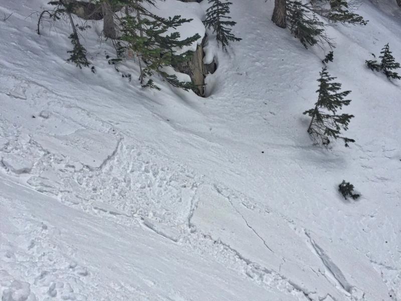
I was able to ski cut this shallow wind slab. Nothing alarming, but it was in a lower elevation protected area that one wouldn't expect. Easy to see today but once covered with new snow, might be a different story.

I've been finding a very stable snowpack lately and have been able to push slope angles without feeling guilty about doing so. That being said, the snow surface is very weak right now and the surface hoar and near surface facets are going to become our next weak layer once buried by this week's upcoming unsettled weather. Not sure tonight's snow will add enough weight to activate this layer though. Nonetheless, today's snow surface will be the next weak layer in our snowpack. Will have to watch snow and water totals tomorrow.

Today's Observed Danger Rating
Low
Tomorrows Estimated Danger Rating
Moderate