Observation Date
12/30/2016
Observer Name
B
Region
Salt Lake » Big Cottonwood Canyon » Brighton Perimeter
Location Name or Route
Snake Creek and Caribou Canyons
Weather
Sky
Clear
Wind Direction
Southwest
Wind Speed
Light
Weather Comments
Winds were out of the SW on the high end of the Light Range speed wise; and sustained and active on the exposed ridgelines. Light Transport was observed with Loading visible. Temperatures were unseasonably Warm with 9000 foot highs in the 30's. Skies remained clear throughout the day.
Snow Characteristics
Snow Surface Conditions
Dense Loose
Faceted Loose
Wind Crust
Melt-Freeze Crust
Damp
Snow Characteristics Comments

SE through SW got damp mid day and began to Crust by late afternoon. Variable surface conditions exist with Widespread Wind Sculpting, Sastrugi, and Wind Board on much of the Upper Elevation exposed terrain. Pockets of settled dense Powder still exists on some NE and N aspects in the Alpine, but the majority of the best riding on settled Powder can be found in Wind Sheltered Shady terrain. Good turning was found on both Steep and Low Angle Terrain. The main problem for this option is avoiding the tracks from snow machines, skiers and snowboarders. It appears that we will get a needed refresh late on Sunday.

Red Flags
Red Flags
Recent Avalanches
Wind Loading
Rapid Warming
Poor Snowpack Structure
Red Flags Comments
Consensus is that most if not all mid pack weak layers are not reactive, yet Snow Pit Tests continue to identify a couple of weak layers high in the pack. There appears to be a Light Density Weak layer 12 cm down that was getting Moderate, Q3 shears; and the other Weak Layer of note continues to be now 30 cm down. This Weak Layer appears to be buried NSF's from last week before the most recent event. The Weak Layer at 12 cm down appeared to be the culprit in the pictured Wind Slab/Cornice Fall Avalanches. The Picture depicts a small pocket that appeared to release within the past 36 hours of Active Winds. Note the debris in the runout zone below that was accumulations of more of the same lower on the ridgeline. In total, it appeared that Cornices released Naturally and the full width of this activity was at least 150 feet.
Avalanche Problem #1
Problem
Wind Drifted Snow
Trend
Decreasing Danger
Problem #1 Comments

See above for Wind Slab details, and below for Picture. Forecast Winds appear to be lessoning, and this Problem may be decreasing by Saturday. No cracking was observed in the Hard and Soft Wind Slabs investigated.

Avalanche Problem #2
Problem
Persistent Weak Layer
Trend
Decreasing Danger
Problem #2 Comments

Still hard to rule out the very Isolated High Elevation Deep Slab possibility on NW, N and NE aspects with the way the Winds have been active in the past few days. As the Winds die down for the next 48 hours this possibility may be more dorment, yet with the incoming forecast Storm for Sunday night and PreFrontal SW Winds, this Problem may be more of concern later in the weekend.

Cornice Development observed today was minimal, yet it was easy to calve off small pieces.

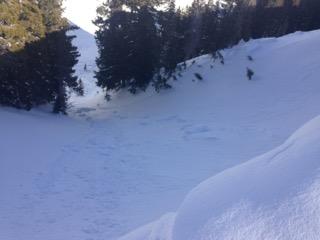
Minimal Wet Loose Activity was observed today.

Finally, the other picture of Roof Avalanche Hangfire in the Brighton Area notes this possible Danger during any future Warming Events. Saturday may not offer enough Warming, but this concern should be noted.

Most terrain has a Low Danger, with Isolated pockets of Moderate for Wind Slabs and very Isolated Lingering Persistent Slabs as described above.

Today's Observed Danger Rating
Moderate
Tomorrows Estimated Danger Rating
Moderate