Observation Date
12/29/2016
Observer Name
Brackelsberg
Region
Salt Lake » Parleys Canyon » Mt Aire
Location Name or Route
Mt Aire
Weather
Sky
Clear
Wind Speed
Calm
Snow Characteristics
Snow Surface Conditions
Powder
Wind Crust
Snow Characteristics Comments
Wind slabs were prevalent on NW through SE aspects.
By 11AM, the SE aspects at 8,500' were already damp and heavy from daytime warming.
Red Flags
Red Flags
Wind Loading
Rapid Warming
Poor Snowpack Structure
Red Flags Comments
Significant wind slabs on upper ridge lines
Very poor snowpack structure in the areas that we did hand pits
Lower elevations could experience wet slides due to the daytime warming.
Avalanche Problem #1
Problem
Wind Drifted Snow
Trend
Same
Problem #1 Comments
Wind slabs were quite dense on all aspects. We felt that these could step into the weaker snow below if they broke.
Avalanche Problem #2
Problem
Persistent Weak Layer
Trend
Same
Problem #2 Comments
The multiple crusts on top of the ground facets were an cause of concern had us avoid these aspects.
Comments
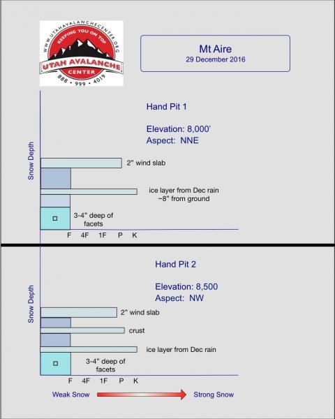
A couple of quick hand pits revealed the very poor snowpack structure on both NW and NNE aspects. There was no early season snow in this area but the December rain reached this elevation and capped the snowpack leading to the faceting of the snow from the Thanksgiving storm. The snowpack was quite shallow at ~24".
Today's Observed Danger Rating
Moderate
Tomorrows Estimated Danger Rating
Moderate