Observation: Moab

Observation Date
12/23/2016
Observer Name
Dave Garcia
Region
Moab
Location Name or Route
Laurel Highway
Weather
Sky
Clear
Wind Direction
Southwest
Wind Speed
Light
Weather Comments
Sunny skies, light winds, beautiful day in the mountains.
Snow Characteristics
New Snow Depth
8"
New Snow Density
High
Snow Surface Conditions
Powder
Dense Loose
Snow Characteristics Comments
About 8 inches of new snow, came in a bit heavier than expected. The dense snow is cohesive enough to form a slab. It made for fun skiing, very supportable and keeps you on top.
Red Flags
Red Flags
Cracking
Collapsing
Poor Snowpack Structure
Red Flags Comments
As fun as the skiing was today, there are still some red flags out there worth mentioning. We got a good collapse on a low elevation, steep, NE facing test slope. The slope initially failed on buried surface hoar, which was fairly widespread at low elevations before the storm. What is interesting is that it failed on the surface hoar and then broke down to the next layer of older snow below the surface hoar (see attached photo). We enjoyed good skiing on west, and southwest before finally digging a pit on a high elevation south facing slope. We found a rather poor snowpack structure on this aspect.
Avalanche Problem #1
Problem
New Snow
Problem #1 Comments
As mentioned earlier the snow came in rather dense and cohesive enough to form a slab. The south aspects formed a sun crust about 1.5 cm thick prior to the storm. The crust seems to have grown small facets underneath it. The weight of the new snow on the crust was causing it to fail on this very small facet layer.
Avalanche Problem #2
Problem
Persistent Weak Layer
Problem #2 Comments

Forecaster comment: As Dave mentioned above, the storm slab failed on buried surface hoar, or the old snow/new snow interface. Additionally, a failure occurred on a deeper weak layer of facets constituting a persistent slab problem. Poor snow pack structure can be found on all aspects at this point with varying degrees of load, or over riding slab on top, and this persistent slab problem isn't going away any time soon.

A note on danger rating: Dave has rated the danger at considerable due to the poor snow pack structure and prevalence of red flags and his concern is warranted. We are very much in the zone where it is possible, or even likely in some areas to trigger a dangerous avalanche. However, since the likelihood for triggering an avalanche wasn't widespread, and natural activity was very unlikely, I rated the danger as moderate for the day.

Snow Profile
Aspect
South
Elevation
11,600'
Slope Angle
29°
Comments
The pit was dug on a high elevation south facing slope at 28 degrees. Total depth was 62cm. I wanted to dig on a south facing slope today to see how that crust layer was interacting with the new snow. The crust is at 49cm. It wasn't quite what I was expecting, but the crust layer was having a very significant impact on stability. The crust failed on the small layer of facets beneath it when we isolated a column for a compression test. It failed on isolation with a very clean Q2 shear. Our pit also revealed a significant layer of facets towards the bottom of the pack at 31 to 20 cm. This layer failed at CT2 Q2. Not very confidence inspiring. We did an extended column test to again test the upper crust layer and it failed ECTP8 with a very clean Q2 shear. Keep in mind this is one pit in one location, but it was enough of a red flag that we skirted the steep rollover below us and opted for a lower angle exit.
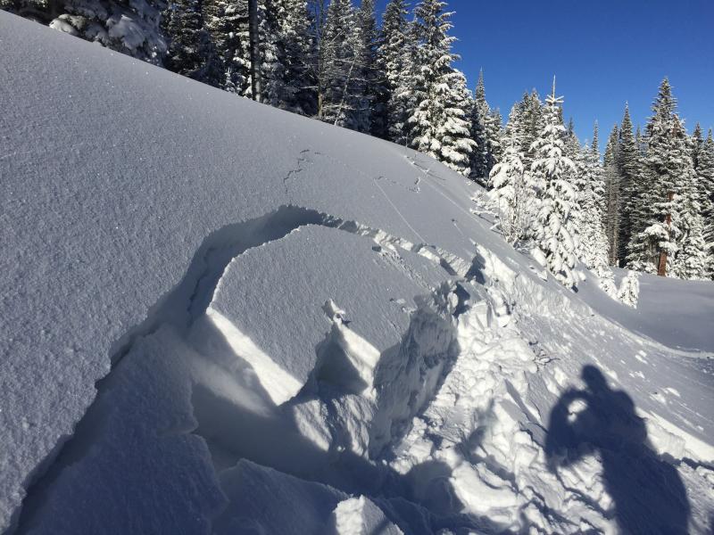
This is the low elevation NE facing test slope. Hard to tell from the shot but it broke down to the next layer below the buried surface hoar.
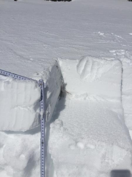
A shot of the storm slab and crust after failing on isolation.
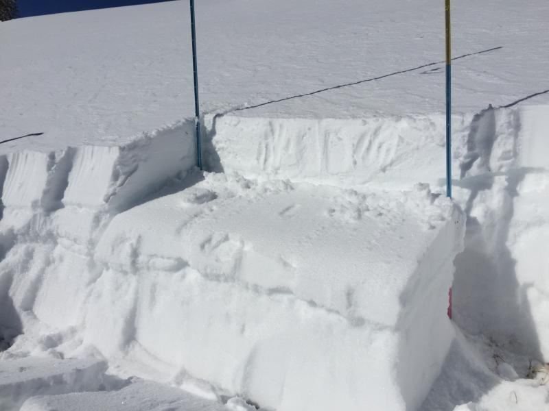
The same layers after the extended column. Failed on the underside of the sun crust at 47.5 cm.
Today's Observed Danger Rating
Considerable
Tomorrows Estimated Danger Rating
Considerable
Coordinates