Observation Date
12/17/2016
Observer Name
Greg Gagne with Dave Pease
Region
Salt Lake » Big Cottonwood Canyon » Mineral Fork
Location Name or Route
Mineral
Weather
Sky
Overcast
Weather Comments
Clearing as day progressed. No wind. Pleasantly cool temps.
Snow Characteristics
New Snow Depth
12"
New Snow Density
Medium
Snow Surface Conditions
Powder
Snow Characteristics Comments

Quite a bit of variety in the snowpack. Was finding evidence of rain up to about 8500' with a supportable crust. At lower elevations snowpack below crust was damp to the ground. Storm snow totals following arrival of cold front are 30 cms (12") at 8500' with 40 cms (16") at 9500'.

HS 100 cms at ~9000' and 130 cms at 9500'

No wind loading evident in our tour today, nor any signs of natural avalanching other than sluffs on steeper aspects. Some pooled graupel at the base of steeper aspects.

Ski cuts on steeper aspects got the top 10-15 cms (4-6") to easily sluff.

Seems like a Steenburg "Goldilocks" storm with right-side up densities with very low-density snow now sitting on the snow surface. (Though we could have skipped the part about rain to 8500')

Red Flags
Red Flags
Heavy Snowfall
Wind Loading
Avalanche Problem #1
Problem
Persistent Weak Layer
Trend
Decreasing Danger
Problem #1 Comments

Was finding 3 or 4 different midpack weaknesses in upper ~60 cms (2') of the snowpack. These weaknesses appear to be a shallow layer of near surface facets, although they also appear to slowly be gaining strength. All tests today were Q2 or Q3 shear quality in these mid-pack weaknesses. Extended column tests did not propagate. The storm snow didn't seem to be enough of a load on these layers to activate them.

Basal facets were a shallow 5 cm layer with evidence of sintering and gaining strength.

Avalanche Problem #2
Problem
Wind Drifted Snow
Trend
Decreasing Danger
Problem #2 Comments

There sure was a lot of wind on Friday, and this created a likely avalanche problem at upper elevations and along ridgelines. But where we were traveling today there was no evidence of wind loading.

Snow Profile
Aspect
North
Elevation
9,300'
Slope Angle
28°
Comments

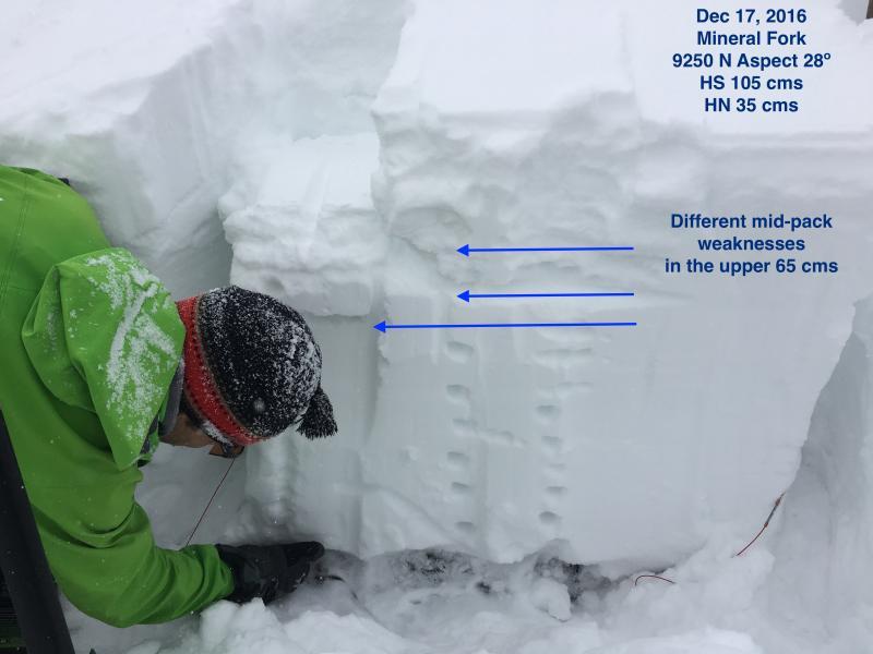
Overall was finding a stable snowpack up to 9500' today in Mineral Fork. Snow pits were showing a right-side up pack that went from F hardness at the surface to 4F and down to 1F near the ground. Persistent weaknesses in upper 60 cms are still a cause for concern, but we were not finding enough of a load today to activate them, and they also appear to be gaining strength.

Photo is of pit (profile above) and my partner Dave Pease looking at basal facets, with arrows pointing to mid-pack weaknesses we identified. Probably the best pit I've dug this year showing generally stable snowpack.

Overall would call today's hazard Moderate, but also did not see any wind affected terrain. Moderate hazard based on:

- no evidence of recent avalanching;

- pit results indicated generally stable snowpack;

- no wind loading;

- no collapsing or cracking.

Could easily imagine a different story in upper elevation terrain that received more snow and wind.

Traveled with solid group today - thanks to my partners Tom Flaherty, Bob Frey, Mark Johnston, and Dave Pease for taking the time to stop and look at snow on a brilliant day of skiing.

Today's Observed Danger Rating
Moderate
Tomorrows Estimated Danger Rating
Moderate