Observation Date
12/13/2016
Observer Name
Paradis / Brackelsberg
Region
Salt Lake » Big Cottonwood Canyon » Greens Basin
Location Name or Route
Silver Fork Meadows / Greens Basin
Weather
Sky
Overcast
Wind Direction
West
Wind Speed
Light
Weather Comments
The day started off clear with cool early am temps. Once the sun came up it started to feel warm. By about 10am high overcast had started to move in which helped to prevent solar warming. Wind was light ascending east facing slopes and a little stronger at ridgetop.
Snow Characteristics
New Snow Depth
8"
New Snow Density
Medium
Snow Surface Conditions
Powder
Wind Crust
Snow Characteristics Comments
Wind from Monday had affected the snow but it mostly skied well once just down off the ridge tops. It appeared that in some places the wind had eroded some new snow leaving grauple on the surface. Wind drifts along the ridge tops were pretty stubborn and difficult to crack.
Red Flags
Red Flags
Wind Loading
Red Flags Comments
Didn't check the poor snowpack structure, since what we saw today was far better than what we normally have for this time of year. Although the more open east facing slope had a variety of layers it didn't seem like there were many obvious shears or burried persistent weak layers/grains. The north facing slope from the second pit may not have been representative but the snow there had pretty decent structure for a pretty thin snowpack.
There had clearly been a substantial amount of wind the day prior which helped to fill in old tracks but also created some hard wind slabs along ridge tops. These could crack with some effort.
Avalanche Problem #1
Problem
Wind Drifted Snow
Problem #1 Comments
Although we were in relatively protected terrain, the wind had clearly been strong so this could have been problematic in more exposed, alpine areas.
Avalanche Problem #2
Problem
Persistent Weak Layer
Problem #2 Comments
Although we did not find extensive facets (most seemed to be rounding), other aspects and slope may contain these weak layers.
Snow Profile
Aspect
East
Elevation
9,400'
Comments
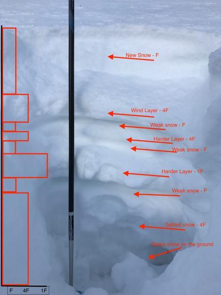
I wanted to look at some north facing snow and was surprised at how thin the snowpack was in this area. This may not be representative of other slopes at this elevation but the structure seemed to be pretty decent with no ECT result and no persistent weak layer grain types that didn't show evidence of rounding.
.
Quick profile shown above shows a more complex situation on this relatively open east facing area. Many of the stronger areas may have been old wind slabs/events. This area had less grauple in the upper snowpack than other areas of recent travel including Grizzly Gulch and Reynolds.
Today's Observed Danger Rating
Moderate
Tomorrows Estimated Danger Rating
Moderate
Coordinates