Observation Date
12/11/2016
Observer Name
Tyler Falk
Region
Salt Lake » Little Cottonwood Canyon » Flagstaff Ridge
Location Name or Route
Flagstaff
Weather
Sky
Broken
Precipitation
Light Snowfall
Wind Direction
West
Wind Speed
Moderate
Weather Comments
Light snow early ended by mid morning. Tempatures were 14 degrees colder at 10k this morning than yestarday. 12 versus 26 degrees yestarday at 10k at 8:30AM. Low elevation sites however struggled to get below freezing overnight. Only 31 degrees at the LCC powerplant at 6am. Winds backed off by early morning compared to overnight readings.
Snow Characteristics
New Snow Depth
12"
New Snow Density
High
Snow Surface Conditions
Dense Loose
Damp
Snow Characteristics Comments

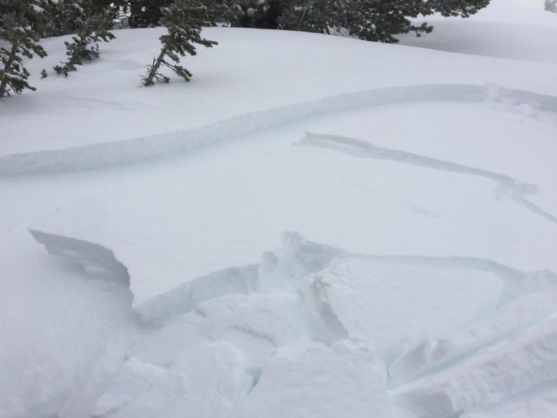
Upper LCC seamed to pick up a foot of new snow in the last 24 hours. Storm total since Thursday night are around 24"(62cm) at 10k. Which is around 12.5% SWE at that location. Looks like most upper elevation sites got between 2 and 3 inches of water weight added to the snowpack. A fair bit of graupel with in the new snow, some of which was rimed. It seamed like the rain line reached around 7700' Saturday afternoon. That did not help build our low elevation snowpack but did do a good job of filling in lots of upper elevation terrain. Height of snow is now 130cm on high north aspects. This storm bought our snowpack in many locations to over 100% of Median. As of 12-11. Still early but nice to see...

Central Wasatch:

Mill D. BCC- 107%

Brighton- 111%

Snowbird-101%

Parleys Summit- 143%

Northern Wasatch:

Ben Lomond Peak -164%

Lightning Ridge- 193%

Southern Wasatch:

Cascade- 112%

Timpanogos Divide- 98%

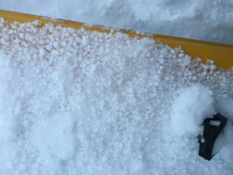
I averaged all ten storms that have been at least 6'" at Alta this year. Those ten storms averaged put us at 11% SWE for the year. Maybe our typical Intermountain snowpack might be headed towards more of a maritime type pack this year. This pineapple express type storm cycle sure felt maritime....

11-17 7%

11-21 12%

11-23 8%

11-27 5%

11/28 8%

11-29 12%

12-8 15%

12-9 14%

12-10 17%

12-11 13% Average 11% As of 12-11

Red Flags
Red Flags
Recent Avalanches
Heavy Snowfall
Wind Loading
Cracking
Red Flags Comments
Transport occuring on 10k ridgelines from west winds. Mostly loading the NE to SE aspects. The higer density snow keep transport to a minumin but there was still plenty of snow to be blown around at the higher elevations. Small 6" slabs pulling out while breaking trail up flag early this morning. Natural on superior ran down to the willows in the lower apron likely late last night or early am.
Avalanche Problem #1
Problem
Wind Drifted Snow
Trend
Decreasing Danger
Problem #1 Comments

Wind slabs will still be around tomorrow although likely less reactive than today. Most commonly found on NE to SE aspects.

Avalanche Problem #2
Problem
Persistent Weak Layer
Trend
Same
Problem #2 Comments

Still not getting on anything in the North half of the compass. Like Evelyn mentioned on the advisory today I think it could be likely that a wind slab or storm slab might have the potential to step down into the old snow in thin areas up up high where the Autumn snow is present. Around 13cm of facets on the ground at 10k on a North aspect where I dug today. (2-3mm) Those squares are now over a meter down so ECT's and CT's wont tell us to much about them. I would be interested to see some PST results in that weak layer in various locations. Places that have already avalanched this year full depth would be my pick for repeaters once we get more of a load.

Comments

A few ECT's and CT's on a North aspect at 10k showed failures with in the storm snow at 10, 25 and 62cm down.

Pic 1. Shallow slabs pulled out while breaking trail up flagstaff this am.

Pic. 2. Lots of Graupel in the storm snow.

Today's Observed Danger Rating
High
Tomorrows Estimated Danger Rating
Considerable