Observation: Little Cottonwood Canyon

Observation Date
12/10/2016
Observer Name
Greg Gagne
Region
Salt Lake » Little Cottonwood Canyon
Location Name or Route
Upper LCC Perimeter
Weather
Sky
Obscured
Precipitation
Light Snowfall
Wind Direction
West
Wind Speed
Moderate
Weather Comments
Winds seemed confined to upper elevations.
Snow Characteristics
New Snow Depth
4"
New Snow Density
High
Snow Surface Conditions
Powder
Wind Crust
Snow Characteristics Comments

Heavily-rimed crystals producing dense, "surfy" conditions. Very shallow 5 - 10 cm (2-4") ski penetrations. Was finding fresh sensitive cornices and dense wind drifts along upper elevation ridge lines. Although it was quite easy to kick the sensitive cornices, the fresh wind slabs were not sensitive to any stability tests. Still, given the persistent weaknesses in the snowpack, I would be suspicious of any wind drifted snow.

HS on northerly aspects 75 - 110 cms (30" - 42")

HS on southerly aspects 45 - 90 cms (18" - 36")

What was especially interesting is that, although you can find some thin crusts on solar aspects, the overall snowpack both on solar and shady aspects does not look all that different with a mostly right-side up snowpack going from F -> 4F - 1F with some interfaces of faceted snow.

Red Flags
Red Flags
Wind Loading
Poor Snowpack Structure
Red Flags Comments
Comments on snowpack structure below.
Avalanche Problem #1
Problem
Persistent Weak Layer
Trend
Increasing Danger
Problem #1 Comments

Yesterday in mid BCC we were finding weaknesses in the upper 20-30 cms (8-12") of the snowpack. However in most instances the weak layers were not sensitive as we were lacking a slab above the weak layer. I haven't been in upper LCC in over a week, and was surprised to find a different looking snowpack where the weaknesses in the upper 50 cms were much thinner, and it was very difficult to get clean shears on any of these layers. The two weakest layers were down 30 and 55 cms respectively, but stability tests were mostly CTN or CT25 - 30 with Q2 shears down either 30 or 50 cms. Extended column tests were ECTX or required 25 or more taps with no propagation, and Q3 shears.

Will call this an increasing danger with additional snow expected. But I am thinking these weaknesses do not look that alarming, and should continue to heal.

Avalanche Problem #2
Problem
Wind Drifted Snow
Trend
Same
Problem #2 Comments

I was only able to find sensitive cornices, and fresh wind drifts were not sensitive to my stability tests. But I would be leery of upper elevation slopes that have drifting from the westerly winds, with cross-loading likely on many upper elevations.

Snow Profile
Aspect
Northeast
Elevation
9,400'
Comments

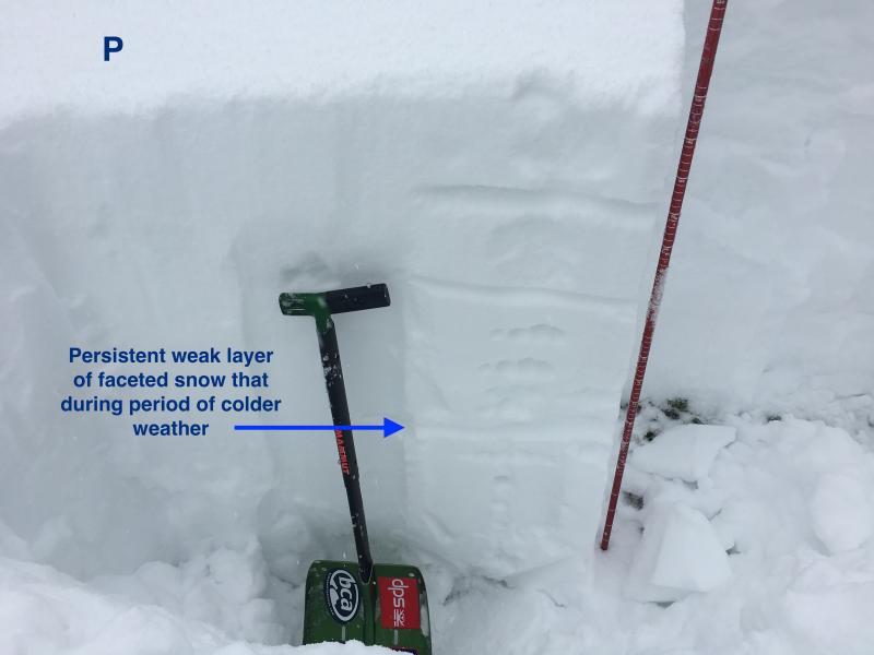
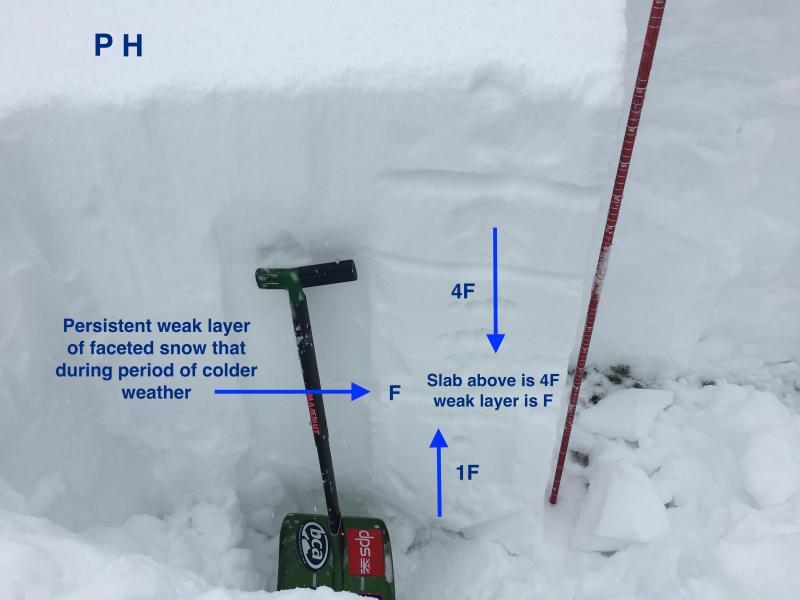
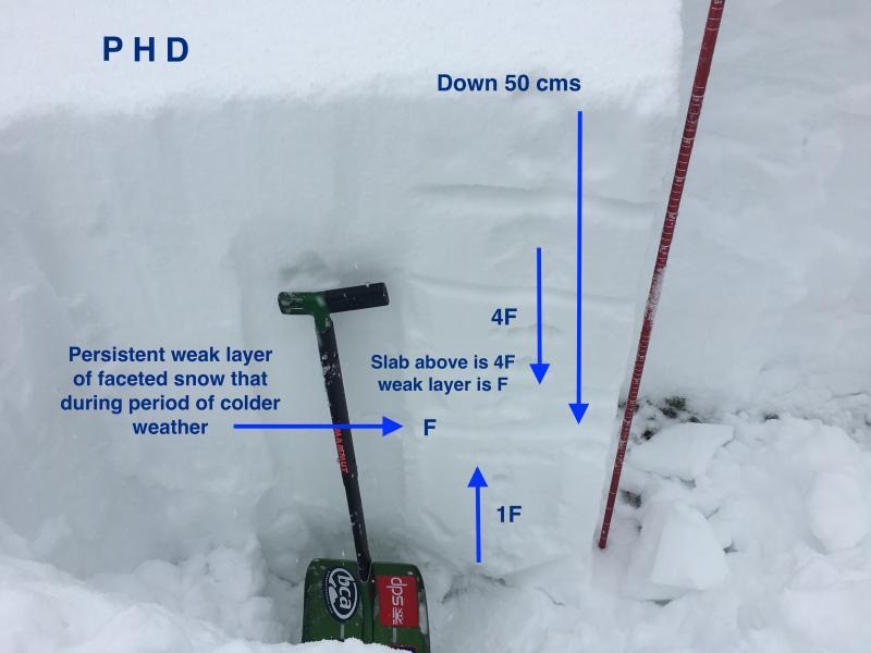
I was talking with UAC director Mark Staples and UAC forecaster Trent Meisenheimer about Ian McCammon's 5 lemons as a way of describing structural weaknesses in a snowpack. A while back, UAC forecaster Drew Hardesty told me the PHD approach, that uses three of the lemons. 'P' is a persistent weak layer (i.e. faceted snow or surface hoar), 'H' is a hardness different across the failure plane between the weak layer and the slab, and 'D' is this weak layer must be less than 1 meter deep in the snowpack. The images below illustrate the PHD of the top 50 cms of the snowpack on a NE aspect in upper LCC. I did not include any stability tests in this discussion as I am instead focusing on only the structure of the snowpack.

Overall was finding a Moderate hazard where I was traveling today in upper LCC. Despite the structural weaknesses in the snowpack, still not finding enough snow to tip the scales that would increase the avalanche hazard. My biggest concern is wind drifting on upper elevations. The dense snow is super fun riding and is supportable for very easy travel.

Today's Observed Danger Rating
Moderate
Tomorrows Estimated Danger Rating
Moderate