Observation Date
11/23/2016
Observer Name
Cody Hughes
Region
Salt Lake » Little Cottonwood Canyon » Alta Ski Area » Pt. Supreme
Location Name or Route
Point Supreme
Weather
Sky
Scattered
Precipitation
Moderate Snowfall
Wind Direction
Southwest
Wind Speed
Moderate
Weather Comments
Began snowing on our exit around 4:30. Stayed up canyon until 6:30 and it was snowing heavily on the drive down.
Snow Characteristics
New Snow Depth
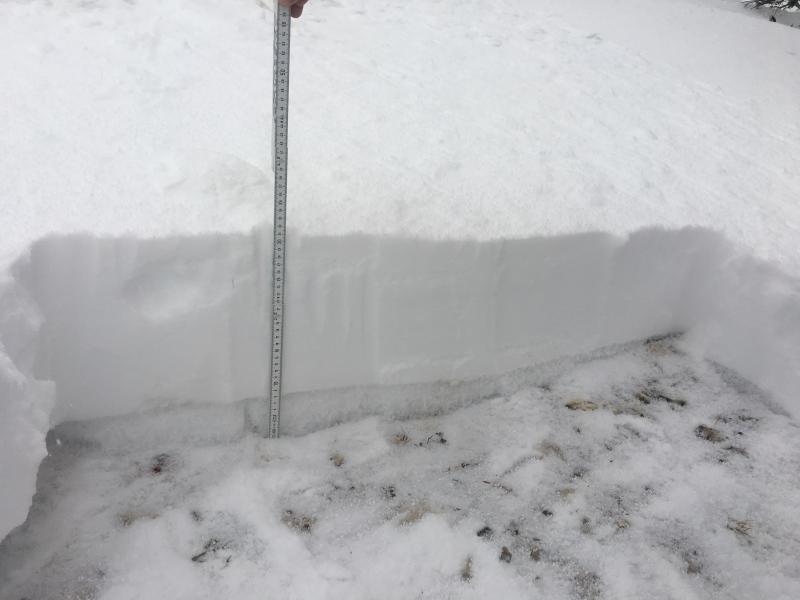
9"
New Snow Density
Medium
Snow Surface Conditions
Powder
Wind Crust
Snow Characteristics Comments
Upside down in places where you were punching through a wind board to powder below. 9 inches of new snow where I dug on top of 3 inches of moist facets.
Red Flags
Red Flags
Heavy Snowfall
Wind Loading
Poor Snowpack Structure
Red Flags Comments
The snowpack structure isn't terrible in locations where the facets are moist and lack connectivity. However, I would think there are protected areas where the facets are more dry and connected, mainly north facing upper elevation terrain.
Avalanche Problem #1
Problem
Persistent Weak Layer
Trend
Increasing Danger
Problem #1 Comments
I would be suspect of slopes facing the north half of the compass both at mid and upper elevations where old preexisting DRY faceted snow can still be found. We are currently lacking a slab, however new snow and wind will change that.
Avalanche Problem #2
Problem
Wind Drifted Snow
Trend
Same
Problem #2 Comments
New snow and wind will form wind slabs along the ridges and in cross loaded terrain. Any wind slab triggered will gouge to the ground and pull the whole snowpack with it.
Snow Profile
Aspect
North
Elevation
10,400'
Slope Angle
25°
Comments
No results with CT or ECT. Really had to pry to get the new snow to move on the facets below. Where I dug the interface was somewhat wet and well bonded.
Today's Observed Danger Rating
Low
Tomorrows Estimated Danger Rating
Considerable
Coordinates