Observation: Moab

Observation Date
3/11/2016
Observer Name
Reed Kennard
Region
Moab
Location Name or Route
pre laurel ridge
Weather
Sky
Scattered
Wind Direction
Southwest
Wind Speed
Moderate
Weather Comments
Warm day at the geyser pass trail head with temps in the low 40's at 10:00 and steady wind out of the south west. Skies were partly cloudy at the beginning of the tour and almost completely over cast by 2:00. Temps around 11,500 ft were still above freezing with continuous winds out of the south west with frequent strong gust. Loose snow could still be seen blowing around along the upper elevation ridges.
Snow Characteristics
Snow Surface Conditions
Powder
Melt-Freeze Crust
Damp
Snow Characteristics Comments
Skiing in sheltered areas was quite good near treeline as long as you avoided areas that had been damaged by the sun. lower elevation skiing was damp and grabby even in shady sheltered areas. Lots of transitional snow up their with ample melt freeze crust to help you build some character.
Red Flags
Red Flags
Wind Loading
Red Flags Comments
Snow could still be seen blowing around at upper elevations ridges. I can't really say their was rapid warming going on because it was quite warm the whole time.
Avalanche Problem #1
Problem
Wet Snow
Trend
Same
Problem #1 Comments
Watch for roller balls and other signs signs of wet instability. The new snow that fell earlier in the week has the potential to slide on sunny aspects as the day warms up.
Avalanche Problem #2
Problem
Wind Drifted Snow
Trend
Same
Problem #2 Comments
This weeks storm came in with a lot of wind and upper elevation northerly slopes are suspect for wind loading. good slope assessment is crucial when thinking about skiing these slopes.
Comments
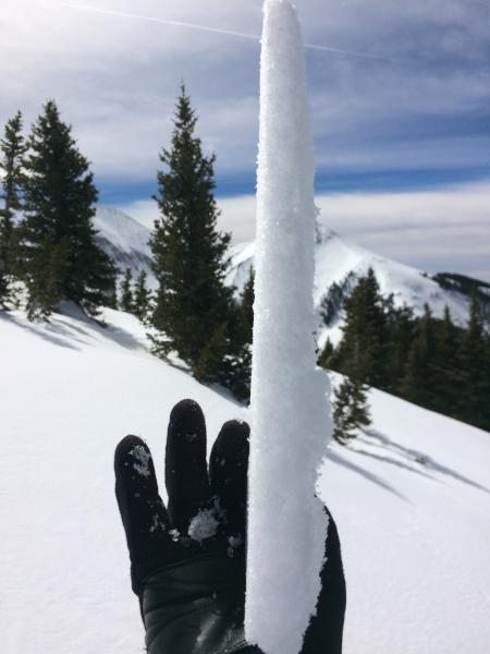
this melt freeze crust was the product of my first few turns
Today's Observed Danger Rating
Moderate
Tomorrows Estimated Danger Rating
Moderate