Observation Date
1/23/2016
Observer Name
Joey Dempster
Region
Salt Lake » Big Cottonwood Canyon » Silver Fork » West Bowl
Location Name or Route
Silver Fork, West Bowl
Weather
Wind Direction
South
Wind Speed
Moderate
Weather Comments
Sunny and windy in the morning. Warm air temps but winds kept snow surfaces from becoming damp above 9000 feet.
Snow Characteristics
Snow Characteristics Comments
Breakable crusts on south aspects, dense settled powder on north. Some wind transport today with shallow, sensitive wind slab formation all morning long and tracks refilling, but there really wasn't much snow to transport from the S faces as they had been baked into substantial crusts the last two days.
Red Flags
Red Flags
Recent Avalanches
Wind Loading
Rapid Warming
Poor Snowpack Structure
Red Flags Comments
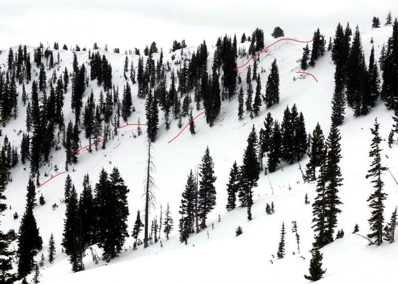
I observed a good sized avalanche from the last few days in West Bowl, half way between the top of West Bowl and Davenport Hill. Details can be found in my avalanche observation. It looks like a repeater, running down to the rocks and facets each time before reloading and running again.
This avalanche is located a few hundred feet down the ridge from a WPG bomb crater that produced nothing, and many sets of tracks in the west bowl. It is an excellent example of variability of the snowpack, and the effect that a few degrees of slope angle can have. This could be a very dangerous slope if it reloads and someone tries to ski it. But more importantly, there are many, many places in the range where similar conditions exist.
Avalanche Problem #1
Problem
New Snow
Problem #1 Comments
I think the main problem tomorrow will be the new storm slab, assuming it continues snowing. The winds today kept the snow surfaces quite cool all morning when they might have otherwise been becoming damp, and when the snow started falling after 1:00 or so, it was falling onto fairly cold snow, and in the case of S facing slopes, slick crusts. The new snow may not bond immediately.
Avalanche Problem #2
Problem
Persistent Weak Layer
Problem #2 Comments
Areas with shallow snow still have faceted snow at the bottom that can be triggered if a new load is placed on it.
Comments
Here is a photo of the West Bowl avalanche, with the crown highlighted in red.
I felt like today's hazard was MODERATE and manageable by avoiding obviously wind loaded starting zones and limiting slope angles to 32-33 and below. However, new snow tonight will bury windslabs and make them harder to see in addition to placing a greater load on them. Also, there is potential for poor bonding between the new and old snow. Tomorrow's hazard will be CONSIDERABLE.
Today's Observed Danger Rating
Moderate
Tomorrows Estimated Danger Rating
Considerable