Observation: Meadows

Observation Date
1/20/2016
Observer Name
Kikkert
Region
Salt Lake » Big Cottonwood Canyon » Silver Fork » Meadows
Location Name or Route
Silver Fork Meadows
Weather
Sky
Obscured
Precipitation
Heavy Snowfall
Wind Direction
Northwest
Wind Speed
Moderate
Weather Comments
Went out for a quick morning during the height of the storm. Snowfall was squally, but generally 2 inches per hour. Winds were hit or miss. Some periods of strong winds in exposed areas, but overall not too out of hand. However, we were never near upper elevation ridgelines where winds were stronger.
Snow Characteristics
New Snow Depth
8"
New Snow Density
Medium
Snow Surface Conditions
Powder
Snow Characteristics Comments

About 4" when we started at 7 AM, 8-9" by 10. Lots or graupel till about 9 when snowfall turned to nice big low density flakes.

Red Flags
Red Flags
Recent Avalanches
Heavy Snowfall
Cracking
Poor Snowpack Structure
Red Flags Comments
We were definitely out at the height of instability, with lots of cracking of the new semi-dense graupel laden snow on top of the lower density snow (with maybe a bit of faceting) from Monday. Would have checked wind loading, but we were fairly protected and loading was minor.
Avalanche Problem #1
Problem
New Snow
Problem #1 Comments

As noted above, new snow cracking very easy. Cracking was mostly limited to right around your skis, as the new snow was not quite slabby enough in most places. However, it was touchy enough that we avoided the steeper slopes. Felt good about this decision when we were able to remotely trigger a large soft slab down low. Activity was likely more pronounced in wind loaded areas.

New snow was cracking on low density snow from Monday. Tried to look at this layer with a lens to look for faceting, but it wasn't super clear. Looked mostly like stellars with maybe just a little bit of faceting. However, some surface hoar may have been involved with our remotely triggered slab (see separate observation).

The new snow instabilities likely settled out quickly in areas after snowfall ceased, but could linger in protected areas where some surface hoar is present (?).

Avalanche Problem #2
Problem
Persistent Weak Layer
Problem #2 Comments

Test pit at 9,500' could get failure on the Jan 10-12 facets, but no propagation and a Q3 shear. Didn't seem overly concerning. Would guess maybe more of a concern on north facing where these facets may be weaker.

Snow Profile
Comments

Danger rating was probably high during the height of the storm, probably more like considerable tomorrow.

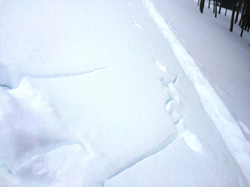
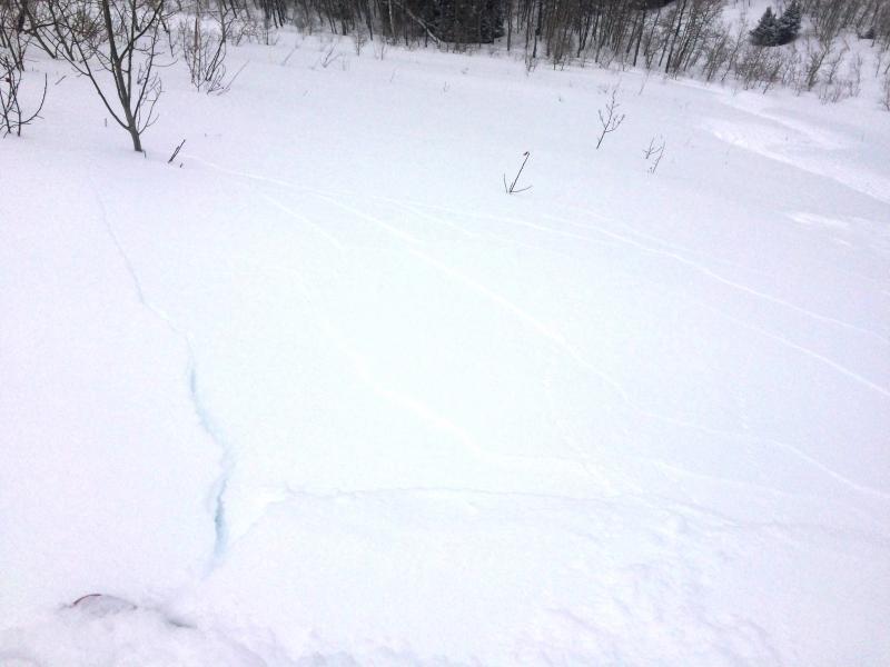
Photos of cracking. Second photo shows cracking on slope where we remotely triggered a shallow soft slab on the slope to skiers left (see separate ob)

Today's Observed Danger Rating
High
Tomorrows Estimated Danger Rating
Considerable