
Snow profile is composite of what we were finding above 9.5K on North aspects. Included the rime layer, but in some pits have also noticed the rime layer decomposing into faceted grains.
Video of discussion of overall snowpack in upper Little Cottonwood.
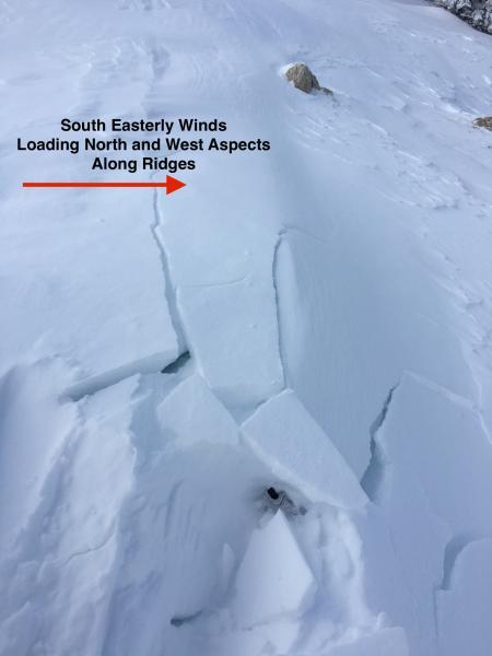
Some wind drifting from SE winds along ridges. Not very widespread, but with very weak snow on North aspects these could create isolated pockets with sensitive wind drifts that could trigger weak layers down at the ground. Even a small avalanche could lead to a very unpleasant (and dangerous) ride over rocks.
Didn't look at snowpack Monday through Wednesday this week, but others (notably Kobernik/Staples/White) reported the old snow surface weakened quite a bit ahead of the Thanksgiving "storm", so I was curious how things looked. The graupel layer from Nov 19/20 is beginning to facet, as well as the layer below. In some areas the rime crust has disintegrated to facets, but on a few pits where the layer is thicker have also seen it preserved, but with facets beneath it.
Stability tests today (quick compression tests) were showing the depth hoar at the ground remains the weakest layer.
On Sunday Nov 22 I was feeling overall ok with our snowpack. Even though it was thin, the only layer of concern was the depth hoar at the ground and I was even noticing some strengthening in the slab above. Not feeling so good any longer as it seems our snowpack has weakened quite a bit. Mark White had a good obs (as usual) from Cardiac Ridge on Thanksgiving where he noticed the snowpack to not have weakened as much in areas where it was thicker.
Currently the hazard is mostly Low with isolated pockets of Moderate on upper elevation north aspects with recent wind loading. However, any change in snowfall or wind loading could be enough to get our weak snowpack to become active.


