Planned Website Outage: The UAC website will be down for maintenance on June 17 from 2:00 - 7:00 PM MT.

Observation Date
3/26/2015
Observer Name
Joey Dempster
Region
Provo » Provo Canyon » Provo Peak
Location Name or Route
Bartholomew Canyon, East Ridge of Provo Peak
Weather
Sky
Clear
Wind Direction
North
Wind Speed
Light
Weather Comments
Wind was light enough that it was only felt once we reached the E-W ridge between Provo Peak and Lama Peak. The difference in snow temperature between the leeward side and the windward side was tremendous. No melting was occuring on N facing slopes that were cooled by the breeze and not receiving direct sun, while S facing slopes were baking, with no air movement to transport heat away. This created a huge disparity in snow and avalanche conditions between the aspects.
Snow Characteristics
Snow Surface Conditions
Powder
Melt-Freeze Crust
Damp
Snow Characteristics Comments

There is about 4-6 inches of settled snow from the Monday-Tuesday storms fell in the Provo Peak area. Today, on south facing slopes, the new snow was "in between" powder and corn (i.e. a sticky mess) because of the cool temps on Tuesday and Wednesday. However, by Friday morning, there will be strong crusts mixed with supportable patches. It will still be a mixed bag for another day or two as the new snow consolidates. On high north facing slopes, it will still be possible to find a few inches of soft dry snow tomorrow, although it would be hard to call it "powder" with slick crusts underneath. The skiing isn't horrible, but it's not great either. It's typical spring "mixed bag" conditions.

Red Flags
Red Flags
Recent Avalanches
Rapid Warming
Red Flags Comments
There was copious evidence of an active, albeit shallow, avalanche cycle after the last storm. There were many small crowns in steep, typically dangerous terrain, and also evidence of wet avalanches that occurred during the first day of strong sun on Wednesday. Most were small due to the small amount of snow that fell, but it does point to generally suspect bonding between that new snow and the old, slick snow surface. That poor bonding was verified by a medium width, shallow (new snow only), slow moving wet avalanche trigger by our party on descent.
Avalanche Problem #1
Problem
Wet Snow
Problem #1 Comments

Our party triggered a WS/WL-D1-R2, 75 feet wide avalanche described below. This avalanche, while not particularly hazardous, entrained all of the new snow from Monday-Tuesday, and resulted from poor bonding to the old snow surface that will likely persist into Friday, and perhaps Saturday as well, although it should diminish quickly as daytime heating penetrates further into the new snow. Until then, all slopes with remaining new snow should be approached with caution. The hazard is manageable, however, and once any weaknesses have been triggered safely, the bed surfaces are safe to descend. Also, the hazard is confined to very steep terrain, certainly above 35 degrees, and in my observation today, closer to 40. I am calling the hazard tomorrow "considerable" in terms of the statistical probability of triggering avalanches in the terrain described here and below. However, the consequences of these avalanches is reduced due the confinement of the hazard to the 4-5 inches of new snow.

Avalanche Problem #2
Problem
New Snow
Problem #2 Comments

While I did not have the opportunity to test N facing slopes today, the presence of numerous small crowns in high elevation N facing steep terrain, and the persistence of the poor bond to old, slick bed surfaces leads me to conclude that it would still be possible to trigger these small, shallow slabs in the new snow in steep N facing terrain. They will be quite manageable and not very hazardous due to their shallow nature. However, deeper wind drifted pockets could present more of a hazard.

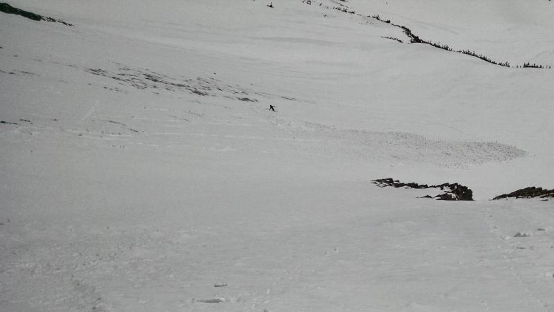
Descending from the East Ridge of Provo Peak at 10,500 feet, the first skier in our party triggered a shallow wet avalanche (WS/WL-D1-R2, 75 feet wide). It had characteristics of both a point release and a wet slab. It propagated slowly, and only a few feet at a time, spreading not like a wide slab avalanche all at once, but in a staggered manner, entraining snow like a sluff for 20-30 feet, then spreading out a bit wider all at once, then back to entraining. It took out all of the new snow (about 4-5 inches) down to the old slick consolidated snow underneath, but did not step down at all. It moved very slowly, and was never threatening. The starting zone was 40 degrees in steepness, and after the slope angle eased off a couple of degrees, the slab characteristics disappeared and the avalanche became a typical wet avalanche. Subsequent turns and slope cuts adjacent to the avalanche path, but lower in the sub-40 degree angled part of the slope did NOT produce any further movement in the snow. The debris traveled a few hundred vertical feet until the slope angle decreased to below 35 and stopped, forming a debris field about 2 feet deep. This particular slide was not destructive or even very threatening, however, on a longer steep slope, it could have entrained more snow and started moving faster, changing the potential hazard.

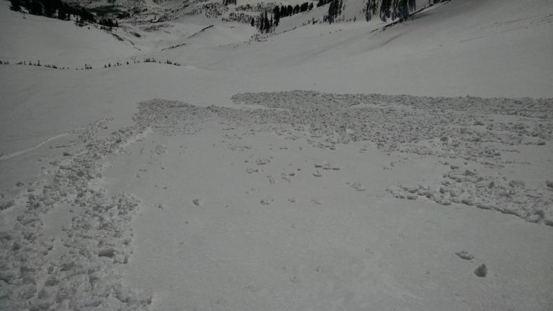
Closeup of debris field generated by the avalanche described above.

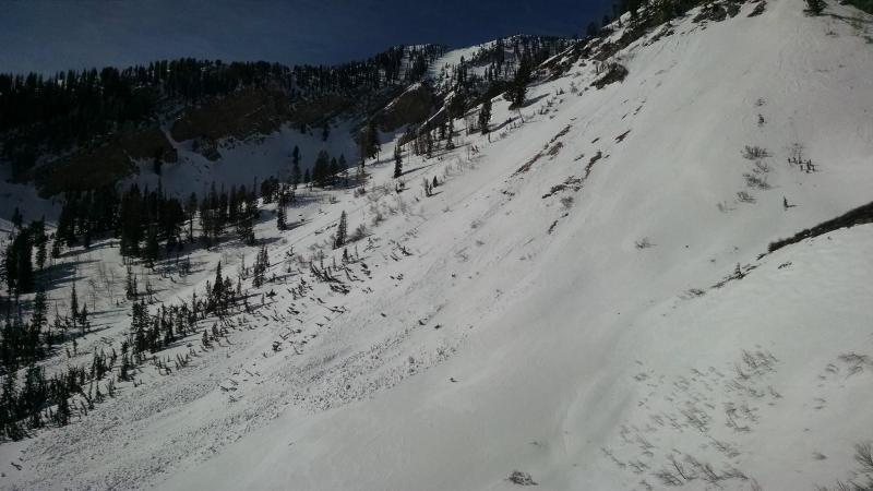
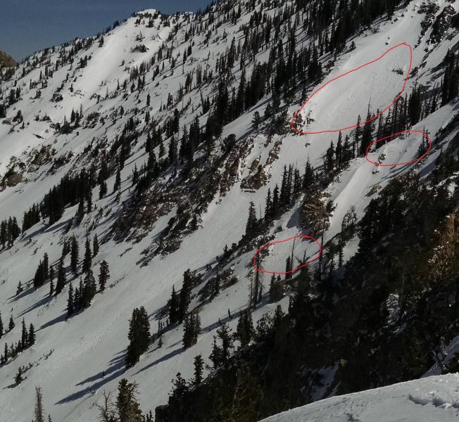
These are examples of the shallow avalanches from days prior to today. The first is lower elevation, about 8000 feet, and looks to be a point release that probably occurred on Wednesday. The second picture is higher, on the NW aspect of Lama Peak (east of Provo Peak) at about 10,500, and shows numerous shallow, small slab avalanches that occurred some time after the storms on Monday and Tuesday. None of these are particularly dangerous avalanches, but they do illustrate the poor bond between the old snow and new snow that will persist into Friday. This poor bonding creates potential for shallow dry slab, wet slab, and wet point release avalanches depending on aspect.

Today's Observed Danger Rating
Considerable
Tomorrows Estimated Danger Rating
Considerable