Observation: Catherine's Pass

Observation Date
11/23/2014
Observer Name
Greg Gagne
Region
Salt Lake » Little Cottonwood Canyon » Catherine's Pass
Location Name or Route
Catherine's Pass Area
Weather
Sky
Overcast
Precipitation
Light Snowfall
Wind Direction
Northwest
Wind Speed
Moderate
Weather Comments
-14 C with sustained moderate winds out of the NW
Snow Characteristics
New Snow Depth
18"
New Snow Density
Medium
Snow Surface Conditions
Powder
Snow Characteristics Comments

Storm snow depths vary due to wind - overall it seems we have about 45-60 cms (18"-24") of storm snow with total snow depths of 80-90 cms (30"-36"). Snow seems rightside up with pretty light snow on the surface and denser snow below. Some graupel evident in the storm (likely during frontal passage on 11/22).

Really noticed spatial variability in snow depths today - wind loading has left some slopes with depths approaching 1.2 meters, while others are much leaner with 45 cms (18") depth. Was finding the stout sun crusts on south and west aspects that Bruce pointed out on Friday as well.

Red Flags
Red Flags
Recent Avalanches
Heavy Snowfall
Wind Loading
Cracking
Collapsing
Poor Snowpack Structure
Red Flags Comments
Very evident, red-flag kind of day.
Avalanche Problem #1
Problem
New Snow
Problem #1 Comments

Early November facets/depth hoar down at the ground are the culprit. Although on some pits I was also finding a layer of near-surface facets that formed this week prior to the storm. Bottom 20-30 cms of snowpack are the weakest. Lots of collapsing and sandboxing on steeper test slopes.

Snow Profile
Aspect
Northwest
Elevation
10,400'
Slope Angle
Unknown
Comments

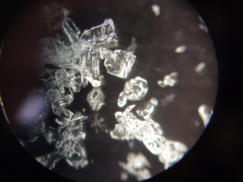
Pretty evident what we are dealing with. Few small storms - Nov 1/2 and Nov 15/16 - left about 20-30 cms of weak faceted snow near the ground. Lots of collapsing and cracking today, and snow stability tests were getting consistent failures down near the ground. The weakest snow is right at the ground with 2-3 mm facets and depth hoar (noticed some cupped depth hoar). Also, the snow that fell 7 days ago weakened (Kobernik captured this pretty nicely) and formed another weak layer on top.

Several pits today - on some slopes couldn't isolate a column, and all ECTs were full propagation, Q1 shears generally failing < 10 taps.

Overall upper elevation east through northwest aspects have the common denominator of weak, faceted snow with numerous collapses and cracking on this layer.

First avalanche course I ever took the instructor told us to give a name to weak layers (i.e. MLK crust.) Since the weakest snow near the ground fell over USAW weekend (Nov 1/2), can we call them the "USAW facets"?

Photo is of faceted snow found near the ground. Like diamonds, facets are beautiful and very dangerous.

Today's Observed Danger Rating
High
Tomorrows Estimated Danger Rating
High
Coordinates