Route this morning was Catherine's Pass & Pt. Supreme. (Original destination was East Bowl of Silver Fork, but strong winds, drifting, and difficult trail breaking made an alternative an easy choice.)
Storm totals since last Wednesday 4/23 are now showing upwards of 60+ cms (2'+) in upper LCC. (Quite easy to identify old snow surface as it is a dusty mess from the 4/22 pre-frontal winds.)
This morning was finding dense, inverted snow with somewhat difficult trailbreaking due to fresh wind deposits. Outside of wind affected terrain, snow was well-behaved and I could only manage some Moderate shears with quick hand pits. These instabilities should heal quite rapidly. However, there is quite a bit of drifting on slopes > 9000' from NW/N winds with some cross loading as well. From top of Collins station at Alta, winds appeared to have ramped up about 4 or 5 am, and they were diminishing throughout the morning while we were out, so it appears to have been a fairly short wind event.
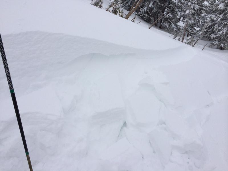
On steeper slopes with wind drifts, it was very easy to get fresh wind slabs to pull out. These were somewhat shallow (15-30 cms) and soft (4F). For the past few weeks we have been dealing with spring snow instabilities which are fairly easy to manage (especially if you pay attention to your watch), however given the now large amounts of new snow and fresh wind drifts, current conditions not as easy to manage. Overall I was finding two weak layers:
1) Lighter density snow sitting below the fresh wind drifts;
2) graupel layer sitting above the 4/22 dust crust.
This morning I was only able to find weaknesses in the fresh wind drifts, however I was out on Sunday as well and in a few places I was digging down to the old snow surface I was still getting clean shears in the graupel layer above the dust crust. it is possible wind slab avalanches could step down to this layer creating large avalanches.
And of course, when the sun comes out we will likely go through a new round of wet avalanches when all this storm snow goes through its first significant warmup.
Where we were traveling this morning, solid Moderate hazard, but possibly higher in steeper wind-drifted terrain.
One of the deeper days of the season ..........
[Photo is of cracking in fresh wind drifts on test slope]
*** BIG THANKS to Bruce for keeping the shop open throughout April. Still noticing lots of people getting after it, so it is much appreciated.


