Planned Website Outage: The UAC website will be down for maintenance on June 17 from 2:00 - 7:00 PM MT.

Observation: Primrose Cirque

Observation Date
4/27/2014
Observer Name
Joey Dempster
Region
Provo » Provo Canyon » Timpanogos » Primrose Cirque
Location Name or Route
Primrose Cirque - Timpanogos
Weather
Sky
Overcast
Precipitation
Light Snowfall
Wind Direction
Northwest
Wind Speed
Strong
Weather Comments
Snowfall today was hardly worth mentioning. More impressive was the wind, blowing steadily above 8000 feet and transporting snow great distances. The sun peeked through occasionally, but not enough to soften the snow surfaces that froze hard in the cold overnight lows. The air was cold all day, and combined with the wind made for winter conditions today, a huge change from yesterday's pouring rain up to 9000 feet.
Snow Characteristics
New Snow Depth
2"
New Snow Density
Low
Snow Surface Conditions
Dense Loose
Wind Crust
Rain-Rime Crust
Snow Characteristics Comments
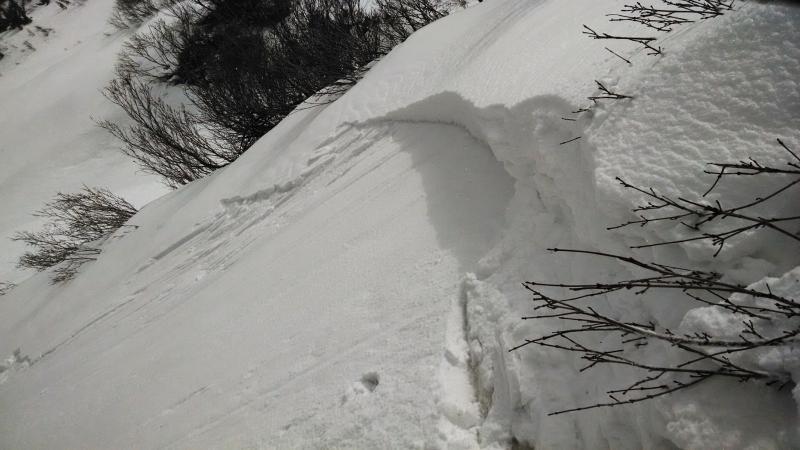
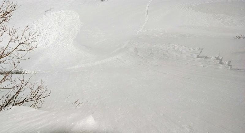
Cold air finally arrived overnight, partially redeeming yesterday's rain disaster. The lowest snow (around 7000-7500 feet) was still saturated and not completely supportable everywhere, but starting at about 8000 the refreeze was more solid and snow surfaces were quite strong. I did not encounter any icy conditions, but some of the wind deposited snow (and there was a lot of that, scattered everywhere, not just along ridgelines) was quite slick. There was widespread debris from yesterday under all of the steep slide paths in Primrose Cirque. The debris was very chunky, indicating to me that the avalanches that left the debris were most likely the result of rain saturating and percolating through consolidated snow until it fractured as a slab. This wasn't relevant to today's hazard, or tomorrow's, but it was interesting to see the effect of the rain on widespread display. More relevant to today and tomorrow was the widespread presence of sensitive wind slabs. I triggered a large 38 degree, east facing test slope very easily. It propagated fast, far, and energetically in the very dense deposition, aided by poor bonding to the slick crust below. The entire slope fractured 20 feet across, and 100 feet downslope to the point where the slope angle eased. It was a perfect wind slab avalanche, propagating as far as the boundaries of the slope permitted it. If the slope had been larger, there is little doubt that the avalanche would have been larger as well. It was not merely a "pocket" that pulled out, but the entire slope. For me, this made the upper reaches of Primrose a no-go today. All of the upper slopes showed evidence of having run already today or yesterday, but no crowns were visible, indicating that they have reloaded from the constant strong winds. Walking up these steep windloaded slopes would have been quite dangerous today, and I believe that with cold temperatures today forecast for tonight will not promote healing for tomorrow. If more snow falls, it will of course be even more sensitive. The skiing up to 9000 feet was quite poor since the refrozen snow surfaces did not soften at all. Below 8000 feet warmer air created better skiing, but there isn't much snow below that. I suspect there could be better conditions higher (dense powder) but I was unable to get higher due to the hazard.
Red Flags
Red Flags
Wind Loading
Cracking
Red Flags Comments
The wind loading is the main avalanche problem for tomorrow. As noted above, test slopes revealed that the wind slabs are poorly bonded, capable of propagating, and potentially large due to high winds and significant amounts of new snow transported long distances from high elevations.
Avalanche Problem #1
Trend
Same
Problem #1 Comments
I would not recommend travel up steep E facing slopes (or any others that may have received deposition) tomorrow. This hazard may be manageable if you can get around the hazard by a safe route and ski cut it before skiing, but on slopes where this is not possible, walking up them is gambling with very poor odds. Areas without windloaded snow have a low hazard of avalanches. Avoid the windloading, and you can travel safely.
Comments
These are pictures of the avalanche that I triggered. It is not wide, but it propagated the entire width of the deposition. It fractured easily, with the first step (without jumping or pounding). At it's deepest, it was about 10". The second picture shows how far downslope the slab propagated. You can clearly see the stauchwall about 100 feet below the crown. The important thing to take home from this avalanche is that the entire slope fractured. None of the wind deposition was well bonded enough to resist fracturing on the steep slope. I would expect that there are many slopes that match this profile of depth and density of deposition, and poor bonding. Walking up or under a larger slope with this snow on it would be very hazardous.
Today's Observed Danger Rating
Considerable
Tomorrows Estimated Danger Rating
Considerable