Observation Date
4/12/2014
Observer Name
Joey Dempster
Region
Provo » Provo Canyon » Timpanogos » Primrose Cirque
Location Name or Route
Primrose Cirque - Timpanogos
Weather
Sky
Broken
Wind Direction
West
Wind Speed
Light
Weather Comments
Cool, breezy, and overcast this morning, although the clouds were spotty and some areas were getting some sun. Although it was not cold overnight again, it was not warm this morning, creating a kind of in-between condition of poor refreeze but no softening of snow surfaces.
Snow Characteristics
Snow Surface Conditions
Melt-Freeze Crust
Damp
Snow Characteristics Comments
Below 8500 feet the snow surface was noticeably unconsolidated and mushy. At about 8000-8500 the dampness disappeared but the snow was generally unsupportable still. Breakable crust and unconsolidated granular snow with the occasional icy patch were the typical surfaces. The skiing was, as it has been all week, quite terrible. I'd settle for "forgettable" at this point, but I'm not holding my breath. I thought this morning's forecast was very astute regarding the effect of the above freezing lows. With the cool-but-not-cold weather, the snowpack is in limbo, neither completely locked up nor falling down around us. But that water is going somewhere and all the unconsolidated snow that might be supportable to skis, but allows a pole to slip easily down 2-3 feet makes me just a little nervous. Hopefully we'll get some decent overnight lows in the coming days to take some of that heat out and firm things up. But until then, it's not quite a "no-brainer" spring so far.
Red Flags
Red Flags
Poor Snowpack Structure
Red Flags Comments
Widespread unconsolidated snow, even at high altitudes, with water percolating through could lead to areas of significant weakness that could collapse unexpectedly. There is quite a bit of friction (and no slab cohesion) in this scenario, so large slides are unlikely, but on steep slopes the result could be dangerous.
Comments
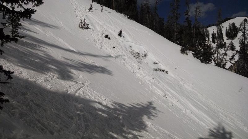
This is actually a photo from Thursday on Mill Canyon Peak, but I didn't submit and observation that day because it was kind of boring and the same as the day before. But I think this photo is interesting in that it illustrates the potential for a sluff from above to give a big enough thump to the snowpack below to ferret out weakness and step down. This particular instance is quite small, but these types of instabilities are no-doubt lurking in other spots, and it pays to maintain safe travel protocols in the event that we end up on the "worst-case" end of the spectrum. This is in steep terrain on the north side of the Mill Canyon Peak true summit (south peak). ~40 degrees
Today's Observed Danger Rating
Moderate
Tomorrows Estimated Danger Rating
Moderate