Observation Date
3/31/2014
Observer Name
Trent Meisenheimer
Region
Salt Lake » Little Cottonwood Canyon » Hogum
Location Name or Route
White Pine - Red Pine - Maybird - Hogum -
Weather
Sky
Scattered
Precipitation
Light Snowfall
Wind Direction
Southwest
Wind Speed
Moderate
Weather Comments
Our day started out sunny and warm at the White Pine trail head. Mid afternoon ushered in thin clouds that kept the heating at bay, although the sunniest aspects became damp and then crusted by late afternoon. Around 3:00 PM it started to snow with moderate to strong southwest winds. Winds were strong enough to drift snow onto lee aspects. Avalanche danger was on the rise and we knew it was time to leave.
Snow Characteristics
New Snow Depth
7"
New Snow Density
Medium
Snow Surface Conditions
Powder
Dense Loose
Faceted Loose
Wind Crust
Melt-Freeze Crust
Damp
Snow Characteristics Comments
We covered a variety of aspects and elevation today in our travels. I completely agree with Evelyn's observation from 10420 - on 3/30/14. The snowpack is highly variable across the terrain. This makes the snowpack tricky for future loading events. Most sunny aspects had about 5-12 inches of snow with a firm crust underneath. However, once tilted just slightly more north (shady) under the new snow the crust was thin enough to punch through into a layer cake of crusts.
Red Flags
Red Flags
Wind Loading
Rapid Warming
Poor Snowpack Structure
Avalanche Problem #1
Problem
Persistent Weak Layer
Trend
Increasing Danger
Problem #1 Comments
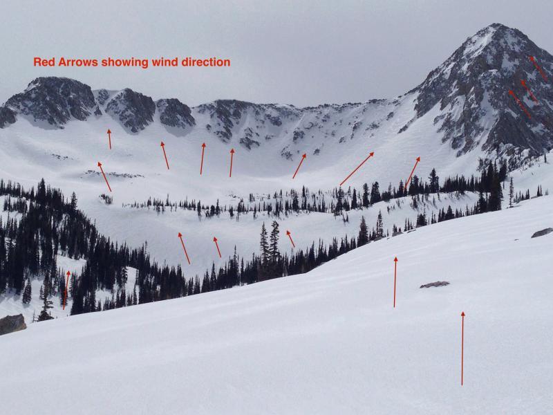
The alpine terrain was mostly wind jacked and you could see the wind ripples (sastrugi) running straight up the north facing terrain. The north west winds created complex slabs throughout the alpine terrain and stripped the most exposed ridges to dirt.
Avalanche Problem #2
Problem
New Snow
Trend
Increasing Danger
Problem #2 Comments
Once down in Hogum we put an uptrack back up towards the Maybird ridge for another lap. This was tricky route finding through some very steep terrain. We kept our skin track tight on a ridge spur in some trees to avoid being under too much snow above. In the trees I found very alarming snow as you could punch your pole through a four finger slab down into very weak (fist) faceted snow at the ground, this was mid elevation NW facing trees - 9700ft. I found it scary enough to change the skin track to avoid walking on the poor structure. I think we were lacking the snow (water weight) and or slab for avalanches today. We did not experience any collapsing or cracking. Height of snow in Hogum was 60-150 cm range, both my dad and I commented on the shallow nature of the drainage.
Comments
Photo of upper Maybird. Red arrows showing wind direction.
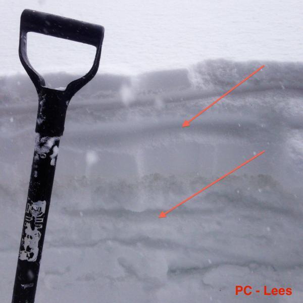
Photo: Evelyn Lees 3/30/14. Great representation of shady mid elevation terrain. Exact mapping of a weak layer would be difficult as this crust, NSF, graupel sandwich varies greatly over a variety of terrain and elevation. Again, I agree with Evelyn that the snow pack has become more layered and the slab seems to be building.
Today's Observed Danger Rating
Considerable
Tomorrows Estimated Danger Rating
Considerable