Observation Date
3/11/2014
Observer Name
Stebbings/Kimbrough/Gagne
Region
Salt Lake » Big Cottonwood Canyon » Brighton Perimeter
Location Name or Route
Brighton Perimeter, Wolverine area
Weather
Sky
Overcast
Precipitation
Light Snowfall
Wind Direction
North
Wind Speed
Light
Weather Comments
Flurry activity during our outing mid morning through just after the noon hour. Winds were calm at times. We did note occassional snow transport on the high ridgelines.
Snow Characteristics
New Snow Depth
8"
New Snow Density
Low
Snow Surface Conditions
Powder
Snow Characteristics Comments
Right side up snow. Nice turning snow. Heard no mention from the group members that they felt the new snow's undergarment (old snow surface) in their turns.
Red Flags
Red Flags
Wind Loading
Red Flags Comments
Noticed some crossloaded pillow development on the Wolverine Cirque steep slopes likely developed late last evening with the strong winds (from whatever direction) which were then covered by the subsequent additional snow overnight.
Barring these pillows we did not come across anything else alarming.
Avalanche Problem #1
Problem
Wet Snow
Trend
Decreasing Danger
Problem #1 Comments
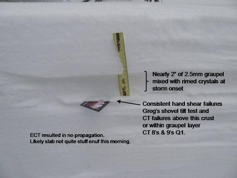
'Problem' may be a strong word as we experienced strictly manageable sluffs on slopes over 30 degrees. Worth a note however is our numerous hand shear pits were revealing the beginnings of some cohesion in soft slab development. We see the new snow instabilities decreasing but I (Keith) personally wonder which will win the race in the next 24-ish hours: Graupel weak layer becoming stronger before the new snow becomes sufficiently slab-like or vice versa?
Snow Profile
Aspect
North
Elevation
10,100'
Slope Angle
32°
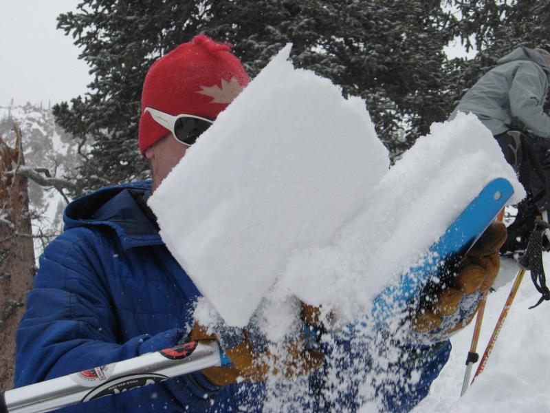
Greg with a fine example of the execution of a shovel tilt test providing further corroborative evidence of the results of our CT's.
Snow geeks we are! but occassionally we let it all hang out. Greg opens the figure 8's and I close them.
The pro's (Tom and Greg) commented that Drew hit the forecast rose spot on today.
Today's Observed Danger Rating
Moderate
Tomorrows Estimated Danger Rating
Moderate