Observation Date
2/21/2014
Observer Name
cammackenzie
Region
Salt Lake » Little Cottonwood Canyon » Grizzly Gulch
Location Name or Route
Grizzly Gulch
Weather
Sky
Broken
Wind Direction
Southwest
Wind Speed
Moderate
Weather Comments
Sunny, high cirrostratus clouds throughout the afternoon, varying in height and coverage. Sun did some affected exposed slopes early created a few small wet point releases around rocks on south facing slopes. Definitely a warming trend, looks like it will continue into the weekend. No precip noted today
Snow Characteristics
New Snow Depth
3"
New Snow Density
Low
Snow Surface Conditions
Powder
Snow Characteristics Comments
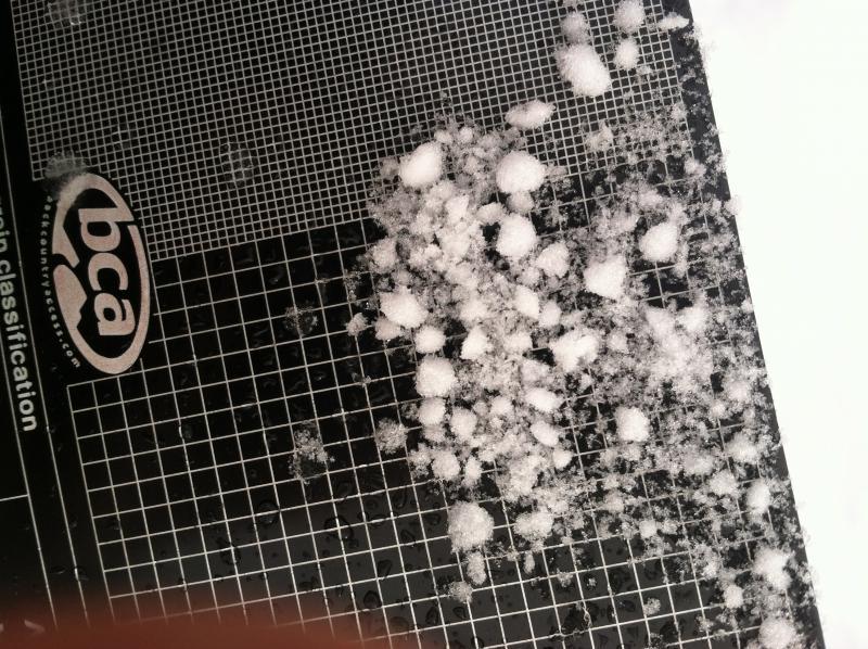
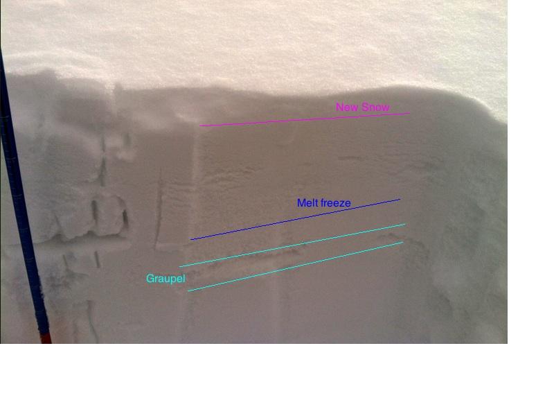
5cm of new snow, mostly plates and stellars from yesterday. under that, roughly 10-20 cm of rimed decomposing snow atop large graupel from previous front and period of high convection. Melt freeze crust formed today on south-southwest facing slopes from warm temps and sun. nothing noted on shaded or west->north->east slopes
Red Flags
Red Flags
Wind Loading
Rapid Warming
Poor Snowpack Structure
Red Flags Comments
Wind Loading- Very active loading along patsy marley ridge, also noted into silver fork, wolverine, etc. bascially everything north and east facing was developing cornices and active loading. Loading also noted farther down slopes than the usual starting zones from previous high winds. Some cornices were getting touchy, remotely triggered one large cornice fall while walking along the ridge roughly 10' away.
Rapid Warming- While driving up LCC, noticed very new point releases in tanners and little superior.
Poor Snowpack Structure- Notes in pit
Avalanche Problem #1
Problem
Persistent Weak Layer
Trend
Increasing Danger
Problem #1 Comments
As previously stated, N-NW facing slopes are being actively loaded. Higher winds have loaded slopes farther down in some places.
Avalanche Problem #2
Problem
New Snow
Trend
Decreasing Danger
Problem #2 Comments
Still buried dragons. Early February's large cycle seems to be ending. I still would be aware of steep E-N-NW facing slopes
Snow Profile
Aspect
North
Elevation
9,200'
Slope Angle
33°
Comments
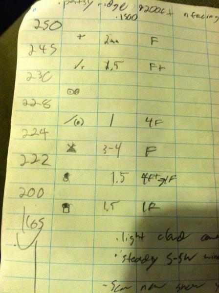
Will edit with a snowpilot pit tmrw. Pit dug in 250cm snow, only went down to 165. Layer of concern by far was at 224, the large 3-5cm graupel created Q1 sheer on SS. ECT failed on the same layer with no propagation.
No slab atop it now, but given a slab and graupel's persistence, this could cause trouble later.
buried melt freeze crust at 228cm
Today's Observed Danger Rating
Considerable
Tomorrows Estimated Danger Rating
Considerable
Coordinates