Observation: Soldier Fork

Observation Date
2/20/2014
Observer Name
Greg Gagne
Region
Salt Lake » Mill Creek Canyon » Soldier Fork
Location Name or Route
Soldier Peak
Weather
Sky
Broken
Wind Direction
Northwest
Wind Speed
Moderate
Weather Comments
Occasional moderate gusts along upper ridgelines. -10C
Snow Characteristics
New Snow Depth
6"
New Snow Density
Medium
Snow Surface Conditions
Powder
Wind Crust
Snow Characteristics Comments

"Storm" totals since Wednesday are about 15 cms in mid-BCC. Cornices are large and somewhat easy to provoke. Some wind drifting along leeward NE aspects with some drifts up to 30 cms noted. Drifts were mostly 1F-hard, though at elevations > 9000 was finding some pencil-hard drifts atop softer snow. Wind drifts were not sensitve to ski cuts however, and at best would only crack locally around your skis.

New snow from Sunday & Wednesday has bonded well to existing surfaces.

Was finding rain & temperature crusts that formed late last week on northerly aspects up to about 9000'. These crusts are now buried under about 30 cms of storm snow from this past Sunday & Wednesday.

HS on northerly aspects between 8500' - 9500' ranges from ~120 to ~180 cms.

Red Flags
Red Flags
Wind Loading
Poor Snowpack Structure
Avalanche Problem #1
Problem
Persistent Weak Layer
Trend
Same
Problem #1 Comments

Winds have been moving snow around as evidenced by continued cornice development as well as wind drifts along leeward ridgelines. However, I wasn't finding them as sensitive as expected. Several quick hand pits below fresh drifts were showing softer (weaker) snow underneath the drifts, and this is never a good combination. I would be most concerned about a stout, P-hard drift that allows you to get far along the slab before breaking out above you. If the winds continue to blow over the next several days, this issue will not quickly go away. If winds subside, am expecting this problem to decrease as well.

Avalanche Problem #2
Problem
Persistent Weak Layer
Trend
Same
Problem #2 Comments

Deep/persistent slab issues remain. In upper elevation LCC on Monday I was finding well over a meter of snow now atop faceted snow near the ground. Am thinking in deeper snowpack areas the likelihood of triggering a slide is low. Today I was finding faceted snow roughly 70-100 cms below the snow surface (this is similar to what Dave Kikkert was seeing in Mineral Fork yesterday) with 4F/1F slab on top. No detailed pits, just lots of quick hand pits and pole probes to identify the depths of the layers of our poor structure.

Comments

Was curious how the winds were affecting the snow surface today and for the most part, despite recent wind loading, was not finding the fresh drifts especially sensitive. They are easily identifiable, and where the drifts are relatively soft (4F/1F) they are manageable with ski cuts. However, where they are stiffer (pencil-hard), they are not easily managed.

Overall am thinking persistent and deep slab issues are working in our favor as the snowpack continues to gain strength. My thinking is - at least in the cottonwoods where there is a deeper snowpack - triggering a deep slab avalanche is becoming increasingly unlikely. But the intersection of probability and consequences is not in our favor. Did ski some steeper E-facing terrain today, but made sure (a) slope was not wind loaded, and (b) was supported (with concavity).

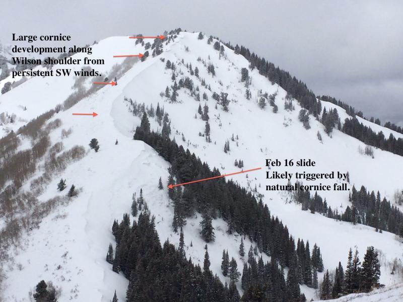
Photo below shows Wilson Headwall with cornice development. Slide on Wilson shoulder (reported by Mark White) visible in foreground.

Am really struggling with identifying avalanche hazard on mid and upper elevation North through East aspects. It may be getting quite close to Moderate hazard, but the consequences are serious. Will continue to label it Considerable for now with recent wind loading in mind. Fortunately ski and travel conditions right now are downright superb and slopes angled in the high 20s and low 30s are skiing great with fast, dense, boot-top fresh snow.

For those with free time, Canadian avalanche forecaster Karl Klassen has a nice blog describing conditions in BC that are not all that unlike what we have here in the Wasatch - http://bit.ly/1h166bD

Today's Observed Danger Rating
Considerable
Tomorrows Estimated Danger Rating
Considerable