Things are still spooky with many large avalanches mostly on upper elevation north through east facing slopes. I went to Cardiff Peak to take photos of the big avalanche in Cardiff Fork that broke 5-6' deep, 1000' wide between Cardiac Pass and the steep rock slabs to the looker's right of it. The avalanche was much smaller than some of the initial reports but still impressive nonetheless. This avalanche ran 2 days ago but was first reported yesterday. I updated the photos on that observation with better ones in the somewhat better visibility today. HERE is the updated report: I just took photos from near Cardiff Peak and did not have time to go into the bowl to do any fracture line profiles. But from the looks of it, a large, deep slab broke out on the weak, depth hoar and faceted snow near the ground. Classic deep slab.
On my way back to Alta from Cardiff, I got a text that two new avalanches had occurred this morning, one near Twin Lakes Pass on the east side of Patsy Marly and another in Wolverine Cirquie. Both were reported to be deep and fairly large. They were reported as naturals by Solitude and Brighton, who could see them, but the Twin Lakes Pass one was triggered by skiers around 10 am kicking cornices.
Brighton utilized a helicopter to do a long-line beacon check of the debris before they found out that it was intentionally triggered from the top. In flying, they noticed a single up track with no exit that was covered by fresh debris. I got there just afterwards and talked to them by phone. I tried to go into it from the north side but there was too much dodgy terrain so I could not quite reach the slide but I could see the single, fresh up track and and the fresh debris so I was coming to the same conclusion that there may be someone buried. I backed off and went around on the ridge and entered from the top in a steep, rocky section and searched the debris with my beacon (no signal) and then noticed an exit track in the trees where it was not visible from the helicopter. So I declared the debris cleared and left. Complete report and photos HERE
I did not have time to look at the natural avalanche in Wolverine Cirque but it was apparently just as deep.
In general, the wallop of very dense snow a couple days ago combined with wind finally pushed the Central Wasatch over the edge of the deep slab cycle that has been so extremely active in all the other outlying areas that had a weaker snow combined with more new snow. Quite a few new slides reported today including on the Park City ridgeline (Radar Love and another one in West Monitor) plus some shallower slides in Dutch Draw, Flagstaff Ridge and other places.
The best strategy right now is avoidance. If you must be on the north through east facing slopes at upper elevations, stay on low angled terrain. Be patient for things to settle out.

 This is the crown face of the avalanches south of Twin Lakes Pass that was intentionally triggered today. 4' deep x 200' wide deep slab to faceted snow just above the old rain-rime crust deep in the snowpack.
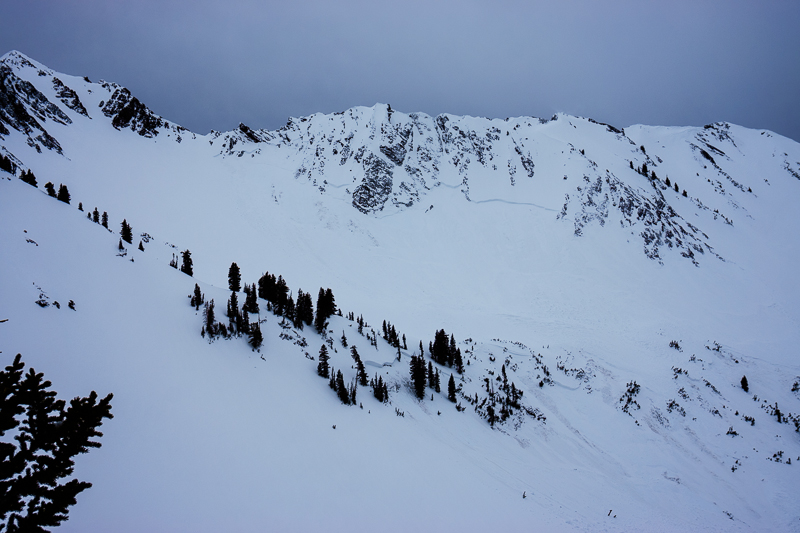 The big avalanche in Cardiff Fork from a couple days ago. You can see the upper fracture estimated to be 5-6' deep, 1000' wide between Cardiac Pass and the rock slabs north of it. It also pulled out deep slabs on the slopes below.


