Observation Date
2/14/2014
Observer Name
jg
Region
Uintas » Upper Weber Canyon
Location Name or Route
Upper Weber Canyon
Weather
Sky
Overcast
Precipitation
Light Snowfall
Wind Direction
West
Wind Speed
Light
Weather Comments
Mild temps; mid to low 30's at 9K, mid 20's at 10K. Light snow but no real accumualation. Light to moderate winds from the W and WNW with strong gusts at times on the upper ridges. Light rain below 9K.
Snow Characteristics
New Snow Depth
3"
New Snow Density
Medium
Snow Surface Conditions
Powder
Dense Loose
Wind Crust
Damp
Snow Characteristics Comments

Wet and damp snow below 9K. 2" - 4" new since yesterday.

Red Flags
Red Flags
Recent Avalanches
Wind Loading
Cracking
Collapsing
Poor Snowpack Structure
Avalanche Problem #1
Problem
Persistent Weak Layer
Trend
Same
Problem #1 Comments

Scary.

Warm temps tomorrow will be something to keep an eye on tomorrow.

Avalanche Problem #2
Problem
Persistent Weak Layer
Trend
Same
Snow Profile
Aspect
Northwest
Elevation
10,400'
Slope Angle
30°
Comments

Traveled from 7400'-10,500', mostly north half of the compass.

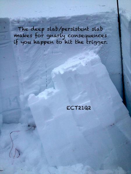
A lot of water weight has been added to the snowpack in the last several days and the buried week layers have been failing naturally. Tomorrow's warm temps will most likely activate these layers in places and definitely make them more sensitive to failure. The avalanche danger is widespread through elevation as the lower elevation terrain has seen rain and snow and upper elevation terrain, snow and wind. Test results reflect a moderate to hard effort to produce failure but weaknesses in the upper snowpack were easier to activate. Step down avalanches are a big concern. I did get one CTX score that failed on 1-2mm facets 18" off the ground.

Consequences are high if you do trigger a slide so terrain choices are critical in travel decisions.

Today's Observed Danger Rating
High
Tomorrows Estimated Danger Rating
High