Observation: Greens Basin

Observation Date
2/13/2014
Observer Name
Greg Gagne with Jeff McCarthy
Region
Salt Lake » Big Cottonwood Canyon » Greens Basin
Location Name or Route
Greens Basin
Weather
Sky
Broken
Wind Direction
West
Wind Speed
Moderate
Weather Comments
Sloppy weather. Damp with occasional moderate gusts out of the West.
Snow Characteristics
New Snow Depth
6"
New Snow Density
High
Snow Surface Conditions
Wind Crust
Damp
Snow Characteristics Comments

Rain/snow line ~7.5K with very wet, heavy snow below about 8800'. When exiting midday, snow at 9400' was getting quite heavy as well. I think I have skiied lighter snow in some early June snowstorms. HS @ 9000 was 140 cms. Some fresh wind deposits were quite sensitive earlier in the morning, although they seemed to stiffen up by late morning. Lots of rollerballs and large tree bombs.

Red Flags
Red Flags
Recent Avalanches
Heavy Snowfall
Wind Loading
Cracking
Collapsing
Rapid Warming
Poor Snowpack Structure
Red Flags Comments
Would add even another red flag with saturated snowpack below about 8000'.
Avalanche Problem #1
Problem
New Snow
Trend
Increasing Danger
Problem #1 Comments

For the past week I have been consistently getting clean shears with full propagation ECTs at or just below a facet/crust layer now buried 70 cms down at 9000-9500' in mid-BCC. Digging a pit today in an area adjacent to a spot I dug on Saturday:

Saturday Feb 8 - ECT11 Q1/SC

Today (Feb 13) - ECT 27 Q1/SC

both failing in the same facet crust sandwich. I do think the super-dense 60 - 75 cm slab now sitting on top of it is a bit more stubborn than results from Saturday, but it is clear to me this weakness is still present. It just may be getting a bit harder to trigger. Am calling for an increasing danger with more water weight plus super warm temps over the next 48-72 hours.

Avalanche Problem #2
Problem
Persistent Weak Layer
Trend
Increasing Danger
Problem #2 Comments

Fresh 4F/1F- hard wind drifts 30 - 45 cms thick were quite easy to instigate earlier this morning. These are sitting on top of some lighter-density snow (Tuesday's snow surface) I was finding these wind drifts to be a bit more stubborn by mid-day when we were exiting. Am guessing they are more widespread in open, alpine terrain.

Snow Profile
Aspect
Northeast
Elevation
9,200'
Slope Angle
25°
Comments

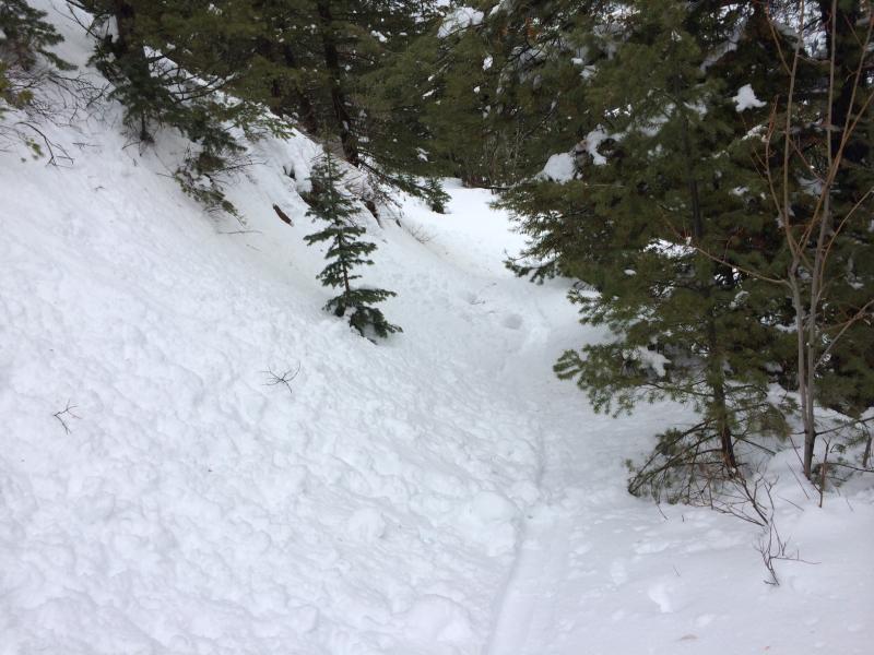
Would add "Avalanche Problem #3" - Wet Slides. At elevations below about 8000' the snow is either saturated from rain or very heavy and wet. Ski cutting test slopes at about 8500' it was quite easy to initiate wet slab avalanches. Photo is exiting skin track where parts of it were obscured from fresh rollerballs and tree bombs.

Quite a mess. Heavy, wet snow with wind loading is likely to bring another round of avalanche activity with lower elevation wet slides, persistent and deep slabs, as well as fresh wind slabs. Would not be surprised to see the expected warming temps trigger wet activity even at mid-elevations where there is some drier snow below the snow surface, as well as upper elevation solar aspects. Am thinking persistent and deep slab instability is currently getting harder to trigger, but any slides would be very large and quite dangerous.

Photos include -

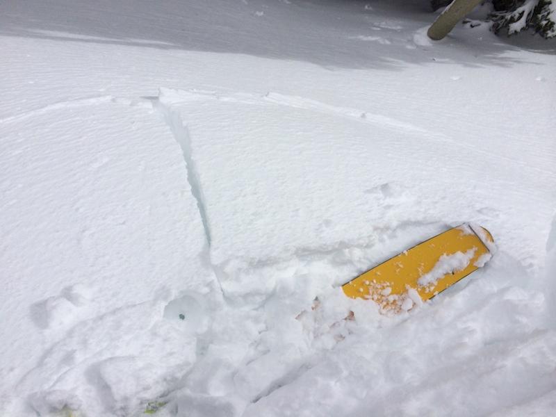
- Cracking in fresh wind drifts

- clean, planar bed surface down about 70 cms from snow surface from excavated pit after performing extended column test (ECT 27 Q1/SC) illustrating facet/crust combo.

With Cottonwood Canyon forecast showing upwards of another half inch of water weight expected, as well as warmer temps, am expecting a High danger for Friday.

Today's Observed Danger Rating
Considerable
Tomorrows Estimated Danger Rating
High