Observation: Bear Trap

Observation Date
1/14/2014
Observer Name
C Brown
Region
Salt Lake » Big Cottonwood Canyon » Bear Trap
Location Name or Route
Beartrap
Weather
Sky
Clear
Wind Direction
Northwest
Wind Speed
Calm
Weather Comments
Nice day, wind finally calmed down.
Snow Characteristics
New Snow Depth
9"
New Snow Density
High
Snow Surface Conditions
Powder
Dense Loose
Rain-Rime Crust
Damp
Snow Characteristics Comments

Snow on the South facing upper beartrap aspens (Beartrap West) was getting damp from the sun today. Nice and creamy feeling. The snow in beartrap glades, WNW facing, was fluffier and drier, but still heavy (skied well). The NE shot down to deso lake was lighter than beartrap glades. Saw the rain/rime crust exposed from the wind up along the ridgeline NW of square top.

Red Flags
Red Flags
Wind Loading
Rapid Warming
Poor Snowpack Structure
Red Flags Comments
South face snow was warming up quick today. Could se the old rotted snow very well even on quick S facing pit. See pit profile. Appeared to be either storm or wind slab sitting on topof some advanced facets. Observed 3 crusts.
Avalanche Problem #1
Problem
Wet Snow
Trend
Increasing Danger
Problem #1 Comments

Could start to see a wet cycle start during the next few days with the high pressure setting up and warmer temps.

Avalanche Problem #2
Problem
New Snow
Trend
Decreasing Danger
Problem #2 Comments

Still have a persistent weak layer(s) lingering in our snow pack just looking for a trigger.

Snow Profile
Aspect
South
Elevation
9,200'
Slope Angle
20°
Comments

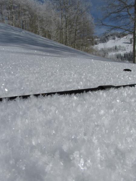
Saw some surface hoar growing already.

Today's Observed Danger Rating
Moderate
Tomorrows Estimated Danger Rating
Moderate