Observation Date
1/10/2014
Observer Name
pierce
Region
Provo » Payson Canyon
Location Name or Route
Payson canyon
Weather
Sky
Broken
Wind Direction
Southwest
Wind Speed
Moderate
Weather Comments
windloading above 7500ft. warm temps and calm at lower elevations.
Snow Characteristics
New Snow Depth
6"
New Snow Density
Medium
Snow Surface Conditions
Powder
Dense Loose
Snow Characteristics Comments
The new snow was varied today with a mixture of powder, in the sheltered areas, and dense loose in the wind blown areas.
Red Flags
Red Flags
Poor Snowpack Structure
Red Flags Comments
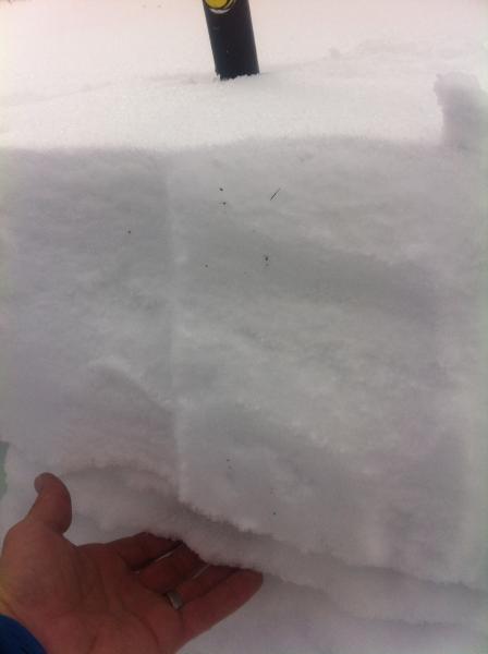
there is a persistent 1cm ice layer from December 20th. It's buried 10"-12" throughout the area. It's sitting on top of 4" of faceted snow, which is sitting on top of another 10" of weak snow, (the lower 4" are moist) then the, large, facet layer at the ground.. The new snow fails on isolation just below the ice layer.
Avalanche Problem #1
Problem
Persistent Weak Layer
Trend
Increasing Danger
Problem #1 Comments
The SSW wind blew all day above 7500'. Cornices and wind slabs continued to build.
Avalanche Problem #2
Problem
Wet Snow
Trend
Decreasing Danger
Problem #2 Comments
lower elevation, terrain trap areas. Temps were in the 40's by 1300 today, creating roller balls and melting snow.
Snow Profile
Aspect
Northeast
Elevation
8,500'
Slope Angle
23°
Comments
In steep terrain, I would expect to trigger avalanches. I would also expect them to fail and then step down into the old, weak layers. Today was a low angle day with little human traffic in the area. Snow totals in this area are still shallow 26"-34" And it's still very likely that snowmobiles will punch through to the ground. ( I tested this theory and it is correct.)
Today's Observed Danger Rating
Considerable
Tomorrows Estimated Danger Rating
Considerable
Coordinates