Observation: Hoyt Peak

Observation Date
2/11/2013
Observer Name
jg
Region
Uintas
Location Name or Route
Hoyt Peak
Weather
Sky
Scattered
Wind Direction
West
Wind Speed
Calm
Weather Comments
Scattered to broken sky with more clouds during the middle of the day, very light wind from the west, light instability showers on and off during the day with little to no accumulation. Cold temps, especially above 8500 ft. Morning lows in the single digits to below zero, afternoon highs in the mid to low teens
Snow Characteristics
New Snow Depth
6"
New Snow Density
Low
Snow Surface Conditions
Powder
Snow Characteristics Comments
Light, fluffy snow. 2" at the trailhead, 6" at 8200 ft., 12" at 10,000 ft. A few density changes within the new snow.
Red Flags
Red Flags
Cracking
Collapsing
Poor Snowpack Structure
Red Flags Comments
I was getting collapsing and cracking on W and NW facing slopes on low to mid elevation slopes where the snowpack is thin and the structure very poor. Cracks were not propagating very far and they was occurring in areas that probably have not been traveled in this season.
Avalanche Problem #1
Problem
New Snow
Trend
Decreasing Danger
Problem #1 Comments
The snowpack is thin below about 8000/8200 ft.; about 2'-3' (61-92cm) and half or more of that is weak, faceted snow to the ground. Above 8200 ft., the faceted snow is getting stronger as a whole but I was still getting positive test results at the interface of the last two faceting events - albeit not very energetic. Seeing that there is no snow forecast in the near future the trend should be toward decreasing danger unless the wind comes into play.
Avalanche Problem #2
Problem
New Snow
Trend
Decreasing Danger
Problem #2 Comments
New snow is not cohesive enough to act as a slab. Sloughing is possible/probable on steeper slopes but seemed manageable today.
Comments
My travels today were from 6800 ft. to just over 10,000 ft. on west thru north facing slopes, slope angles to 35ยบ. The trees were holding most of the new storm snow so there most likely was not much wind after the initial front moved through on Friday night. Test pit pit at 10,000 ft. on a west facing slope - CT test results were CT18-25Q2/Q3. No propagation on ECT. Again, not enough new weight with this storm to activate the weak faceted snow, that's not to say a trigger, like a skier or a snow machine would be enough to get things moving, especially on mid to low elevation slopes or in thin, steep upper elevation terrain. Overall the trend will be toward decreasing danger especially if the wind doesn't blow hard or it doesn't get too warm. Possible faceting of the new snow surface with the cold temps forecasted this week.
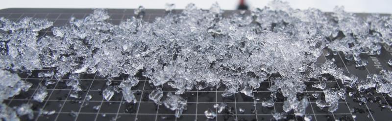
Basal facets on a 3mm grid.
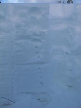
Three distinct slabs within the snowpack. All three showed results in my tests today. All failing on 1-2mm faceted snow.