UDOT PLANNED AVALANCHE CLOSURES!!

Observation: Dessert Shot

Observation Date
12/28/2012
Observer Name
Max Forgensi
Region
Moab
Location Name or Route
Pre-Laurel-Dessert Shot-Northwoods-Pre-Laurel Wx Station-Northwoods
Weather
Sky
Scattered
Precipitation
Light Snowfall
Wind Direction
West
Wind Speed
Light
Weather Comments
A very rare storm system for the La Sal Mountains. Storm #5 begins 12/18. Cleared after 20cm Hst. HS=80 cm Storm #6 begins 12/24. Cleared 12/26. Hst=60cm. HS= 120 cm good settlement Storm #7 begins 12/27. Cleared 12/28. Hst=45cm. HS= 135 cm...settled 10 cm overnight. No wind during Storm #7. Total storm snow at Gold Basin for December to date = 182 cm.
Snow Characteristics
New Snow Depth
12"
New Snow Density
Low
Snow Surface Conditions
Powder
Snow Characteristics Comments
Very light and supportable. Fist to 4F to 1F overlying a 20cm layer of 4F depth hoar on the ground on Northwest thru Southeast aspects. Wind loading evident. Limited signs of natural activity, although where observed large and stepping down to the ground.
Red Flags
Red Flags
Recent Avalanches
Heavy Snowfall
Wind Loading
Poor Snowpack Structure
Red Flags Comments
Interface with depth hoar layer at the ground still able to be triggered by a humans stress bulb in the right trigger point.
Avalanche Problem #1
Problem
Wet Snow
Trend
Increasing Danger
Problem #1 Comments
Sunnier days are forecasted and snow is starting to drop from trees and cliff bands producing loose snow sluffs.
Avalanche Problem #2
Problem
New Snow
Trend
Same
Problem #2 Comments
No wind, tons of light fluffy powder. It is tough to understand there is some risk with high consequences on slopes that hold the early season snow stratigraphy.
Comments

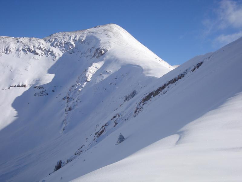
Photo below is of Laurel Saddle...NW aspect @ 11,700'. SS-N-R5-D2.5-WI stepping to ground. The avalanche extended to the flats in Horse Creek. 2' crown near ridge, stepping down to entire pack 1/3 way down.