Observation: Park City Ridgeline

Observation Date
4/4/2026
Observer Name
Malone, Morgan, Kemp
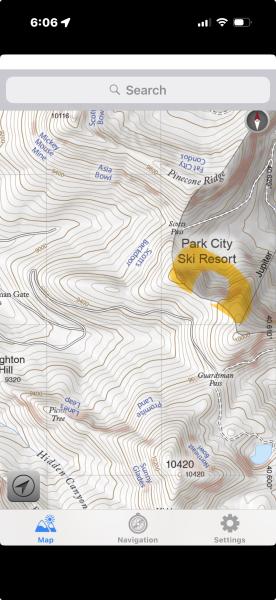
Region
Salt Lake » Park City Ridgeline
Location Name or Route
PC Ridgeline
Weather
Sky
Clear
Wind Direction
Southwest
Wind Speed
Light
Weather Comments
Beautiful blue sky day with intermittent light winds on the ridges. Strong solar input with intense warming throughout the day.
Snow Characteristics
Snow Surface Conditions
Powder
Dense Loose
Melt-Freeze Crust
Damp
Snow Characteristics Comments

Multiple hand pits on N and NW at 9800' identified a MF crust/ old snow surface approx 16" deep (in an area of wind deposition), and the interface between Wednesday's and Thursday's storms approx 12" deep on which avalanches were failing yesterday. Hand shears varied from sudden planar to resistant planar and the interface was easy to find.

Solar aspects are rapidly losing snow and travel is becoming more challenging with sagebrush and dirt patches.

NE and NNE warmed enough to be wet. The only truly cold snow was on due N in the shade of dense trees.

Red Flags
Red Flags
Recent Avalanches
Rapid Warming
Poor Snowpack Structure
Avalanche Problem #1
Problem
New Snow
Trend
Decreasing Danger
Problem #1 Comments

Yesterday's storm slab avalanches acted (briefly) like PWL avalanches (remote triggers, widespread connectivity, propagation of slab well uphill from the trigger), even though they were failing on the storm interface, not a persistent grain type. I'm guessing this was from the combination of new snow with a variety of grain types (DF, graupel, stellars), wind transport, and the rapid spring warming/ solar input. Today, we found decreased sensitivity in the areas we travelled, consistent with rapidly settling storm slab.

Avalanche Problem #2
Problem
Wet Snow
Trend
Same
Comments

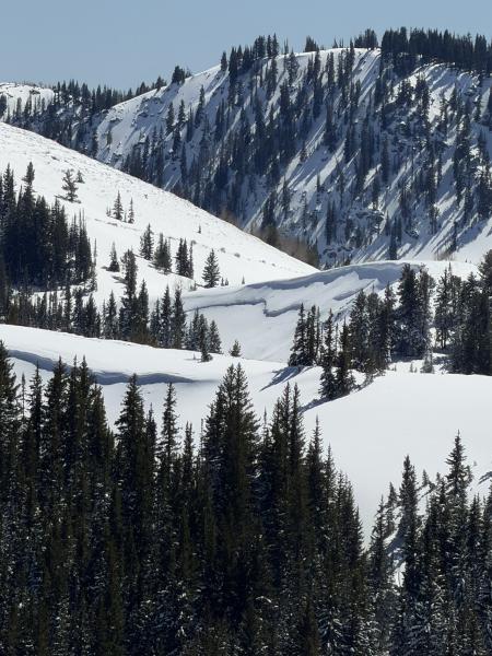
We saw one avalanche that likely occurred yesterday N 9800' in the (now closed) PCMR terrain. No tracks observed but we couldn't see the whole crown face. It could have been triggered remotely given how close it is to the PC ridgeline. I didn't see this one in the many reported; apologies if duplicate. See pic.

Today's Observed Danger Rating
Moderate
Tomorrows Estimated Danger Rating
Moderate