Observation: Mt. Watson

Observation Date
3/27/2026
Observer Name
Climaco
Region
Uintas » Mt. Watson
Location Name or Route
Mt. Watson
Weather
Sky
Scattered
Weather Comments
Gorgeous day out there. 38° at the trailhead at 9:00, tee shirt weather by 11:00
Snow Characteristics
Snow Surface Conditions
Melt-Freeze Crust
Snow Characteristics Comments

With the colder overnight temps we had a fully supportable surface until at least 12:30. Things started softening by 11. At 12:30 when we began our descent we still had a relatively hard surface at 11,500’ on a 55° E facing slope. Down at 10,500’ the surface was considerably softer with a very slashable corn layer.

Red Flags
Red Flags
Rapid Warming
Poor Snowpack Structure
Red Flags Comments
We felt very confident on the slope throughout the morning as the colder temps locked things up tight. That said, on a day without a freeze the night before I would be nowhere on or under this terrain.
Avalanche Problem #1
Problem
Persistent Weak Layer
Trend
Same
Problem #1 Comments

The biggest issue with the Uinta snowpack right now is the two weak layers buried between approximately 35 and 60cm below the surface. Total snow depth was 95-145cm.

This conclusion was supported by the ECT we performed at 10,700’ on a 35° E facing slope. The notable snowpack features included a dense and saturated slab of roughly 40cm sitting atop two weak, faceted layers from January. Below these layers the snow lost much of its integrity and consisted of sugar like rounded facets. This sugar was sitting on a rocky ground bed that crated many variations in elevation and several air pockets.

We recorded a relatively weak ECT 9 with the aforementioned slab failing on the lower of the two January weak layers. As seen in the photo the slab remained intact as it failed. Landing on my leg I could feel just how heavy and dense the surface slab was. So, while everything felt great during the first half of the day, this structure is nothing ti fool around with. The weight and integrity of the slab tells me it is probably very well connected and any fracture will have the potential to propagate widely. We’re talking tree-snapping power here and such avalanches would be 100% unsurvivable. So, get in, get it and then get the hell outta there.

Avalanche Problem #2
Problem
Wet Snow
Trend
Increasing Danger
Problem #2 Comments

While we did not experience any signs of wet snow activity, we did see debris on the slope which appeared to originate from a cornice fall. It was obvious that the slide entrained a significant amount of wet surface snow and ran roughly 800’ and created a debris pile about 3’ tall.

Later in the day or on a day without a freeze, this will absolutely be a threat.

Snow Profile
Aspect
East
Elevation
10,700'
Slope Angle
35°
Comments

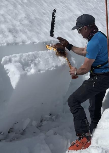
Travel is pretty rough right now. Only 1-2’ of snow on the MLH and many spots of bare pavement are opening up. However, once you get up to about 9,500’ things do improve and riding gets decent. That said, the snowpack is very thin and deadfall is melting out all over the place which makes boondocking tricky. In addition, streams are opening up, as I found out when I sank my sled into calf-deep water when a solid looking bridge collapsed.

bottom line, get it while you can ‘cause it ain’t gonna last long!

Today's Observed Danger Rating
Moderate
Tomorrows Estimated Danger Rating
Moderate
Coordinates