Observation: Deer Valley Perimeter

Observation Date
3/17/2026
Observer Name
Hardesty, Torrey, Morrison, Deer Valley avalanche office
Region
Salt Lake » Park City Ridgeline » Deer Valley Perimeter
Location Name or Route
Deer Valley Perimeter
Weather
Sky
Clear
Wind Direction
Northwest
Wind Speed
Light
Weather Comments
Warm - many stations hit the upper 40s to mid-50s. Marginal refreeze at 8400' overnight with temps only dipping to 36 degrees Monday night/Tuesday morning, though the long wave radiation helped... Some of the stations along the higher ridgelines dipped to 32 and 33 degrees Monday night/Tuesday morning.
Snow Characteristics
Snow Surface Conditions
Melt-Freeze Crust
Damp
Snow Characteristics Comments

Good, supportable corn through the (very) early afternoon hours.

Red Flags
Red Flags
Rapid Warming
Poor Snowpack Structure
Red Flags Comments
Rapid warming just starting to occur with a poor snowpack structure that may produce wet loose and wet slabs in the near future. There are many crusts and/or faceted layers where meltwater could pool and cause wet slab failure.
Avalanche Problem #1
Problem
Wet Snow
Problem #1 Comments

Numerous snow profiles in uncompacted terrain.

99° East @ 9210' below. HS ~85cm. Supportable and frozen crust comprised the upper half of the pack; the lower half was mostly comprised of larger, more coarse loose melt freeze grains, and this is where - unsurprisingly - the liquid water pooled at this interface.

We used colored water to visualize where meltwater is likely to pool in the coming days as temperatures rise. In this snowpit on a north aspect @ 9000'. HS 100cm. (Snowpilot profile below). We observed the water pooling on a midpack crust above a layer of facets. We suspect this layer of facets is the Dry January layer and the crust was from a rain event February 24-25. Regardless, there were multiple locations within the snowpack meltwater was pooling and therefore there is a high amount of uncertainty as we move into a historically warm period for this time of the year.

Snow Profile
Aspect
North
Elevation
9,000'
Comments

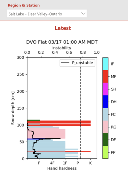
A great deal of thanks goes to the Deer Valley avalanche office, Mark Chytka and Dan Ward in particular. We very much appreciated their hospitality and perspective on the structure and upcoming heat wave. We also wanted to ground truth the Ontario snowpack model, courtesy of Travis Morrison, PhD, working via Chad Brackelsberg and the Utah Avalanche Center through a grant from the Utah Department of Outdoor Recreation to build the Utah Computer Assisted Avalanche Support Tool (U-CAAST). You can learn more about this YouTube presentation HERE and via podcast HERE.

Ontario weather station - 9100' along the south end of the PC Ridgeline at Deer Valley.

Model output for today - 9100' "flat" terrain. It should be noted that the snowpack was not yet isothermal. See snowpilot -

Video
Today's Observed Danger Rating
Low
Coordinates